Science1 publisherNot yet confirmed elsewhere2 min readPublished
Landsat images show farmland and aquaculture along Thailand's Bang Pakong River under water
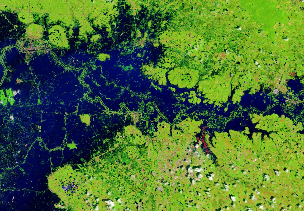
NASA's Landsat images show farmland and aquaculture along Prachin Buri's Bang Pakong River flooded on 2 October 2026, set against the same season in 2025. The pair is strong evidence of how far the water spread that day and weaker evidence of what caused it.
The Scientist · Science desk
What happened
- Persistent heavy rain broken by intense downpours left low-lying parts of Thailand under sustained flooding through late September and early October 2026.
- Since mid-September, floods have reached 50 provinces and affected more than 4 million people, with dozens of deaths, according to the Red Cross and Red Crescent federation.
- In the false-color Landsat frames, the bright red shapes are floating solar arrays.
Compiled by The ScientistSomething wrong?How this is made
Why it matters
- cost Rice farmers and fruit growers bear farmland damage the government puts near 2,700 square kilometres; the Prachin Buri frames show one river corridor of that total.
- constraint The control is one season, 2025, so the comparison measures this year's water against last year alone; ranking it against the province's flood history needs more years of imagery.
- exposure Owners of the floating arrays get a dated record of flooding around their sites, but arrays built to sit on water are not shown damaged by these frames, and NASA's account reports no damage.
The design is a before-and-after comparison, and the earlier frame is the control. Both images cover the same stretch of the Bang Pakong River at the same time of year, one in 2025 and one on 2 October 2026 [2]. September falls in the middle of Thailand's monsoon season, when afternoon rain and thunderstorms are routine [6]. Wet ground in a single autumn photo would be expected. Comparing it with the year before is what picks out the excess, and the false-color rendering is chosen to separate water from vegetation and developed land [3].
Two frames are two moments. They show where water lay on one day. They cannot show how long it had been there or how long it stayed. NASA's description of sustained flooding comes from its account of weeks of rain [1].
On cause, the account hedges. "Some of the flooding likely stemmed from a low-pressure system that stalled over the area for several days in late September," Lindsey Doermann wrote for NASA Earth Observatory [13][5]. Moisture and energy from the warm Gulf of Thailand fed that system and made its rain especially intense, the account says [14]. The rain figure it offers comes from news reports out of Bangkok, about 100 kilometres west of the imaged fields [8]. There, 48 hours brought about 87 percent of an average September's rain [12]. That is a heavy two days for Bangkok, measured in a different place from the farms in the frames.
I think the pair supports one claim firmly. The farmland and aquaculture facilities along the river were inundated on 2 October, and the 2025 frame of the same season is there for contrast [2]. A stalled, Gulf-fed system is a plausible source for some of that water. NASA goes no further than "some" and "likely" [13].
That leaves the image record and the weather record doing separate jobs. Landsat fixes the extent of the water on one date. The weeks-long persistence and the stalled system both come from the rainfall narrative and the news reports it cites [1][8].
What to watch
- Further Landsat passes over the Bang Pakong corridor later in October would show how long fields and aquaculture sites stayed under water.
- Rainfall totals measured in Prachin Buri itself would test how much of the local water the stalled late-September system delivered.
- A province-by-province breakdown of the government's 270,000-hectare farmland damage estimate would show Prachin Buri's share.
Clarity's read
What the record supports and how the coverage leans. The claims behind it follow.
Reality
- Evidence65
- Adoption
- Insufficient
- Hype gap−5
- Incentives
- Insufficient
- Confidence60
Claim ledger
Ranked by verification strength, evidence, and original report placement.
- [1]
Throughout late September and early October 2026, persistent heavy rains punctuated by intense downpours left low-lying areas across Thailand under sustained flooding.
- [2]
Prachin Buri province was among areas where flooding was widespread; a Landsat image shows land along the Bang Pakong River and nearby agricultural areas and aquaculture facilities inundated on October 2, 2026, beside an image of the same area at the same time of year in 2025.
- [3]
The images were acquired with NASA-USGS Landsat satellites and are false-color to better distinguish water from vegetation, developed land, and other surfaces.
- [4]
Government agencies estimate about 270,000 hectares of farmland, including rice fields and fruit orchards, have been damaged.
ReportedSupportedSource: Thai government agencies, as cited by NASA2 sources— create a free account to open themView cited source - [5]
NASA Earth Observatory images by Lauren Dauphin using Landsat data from the U.S. Geological Survey; story by Lindsey Doermann.
- [6]
September falls in the heart of the monsoon season in Thailand, where cities and towns are accustomed to afternoon rains and thunderstorms.
- [8]
About 100 kilometres to the west, Bangkok received nearly 300 millimetres of rain over a 48-hour period, according to news reports.
- [9]
The average monthly rainfall total for September in Bangkok is 344 millimetres.
- [10]
Since mid-September, flooding has occurred in 50 provinces across Thailand, affecting over 4 million people and causing dozens of deaths.
ReportedSupportedSource: International Federation of Red Cross and Red Crescent Societies, as cited by NASAView cited source - [11]
About 270,000 hectares of damaged farmland is roughly 2,700 square kilometres.
- [12]
Bangkok's 48-hour total was about 87 percent of its average September rainfall.
- [13]
"Some of the flooding likely stemmed from a low-pressure system that stalled over the area for several days in late September."
- [14]
Stoked by moisture and energy from the warm Gulf of Thailand nearby, the system delivered especially intense rains to the region.
Sources
1 independent publisher whose own reporting we read for this story.
- nasa.govFloodwaters Overwhelm Thailand
1 article · October 8, 2026
Topics and entities
Follow any of these and your For You feed starts watching them — no settings page required.
Topics
- FloodingFollow
- Satellite Earth ObservationFollow
- MonsoonFollow