Science1 publisherNot yet confirmed elsewhere3 min readPublished
Landsat 9 photographs three boreal rivers pouring tea-brown water into James Bay
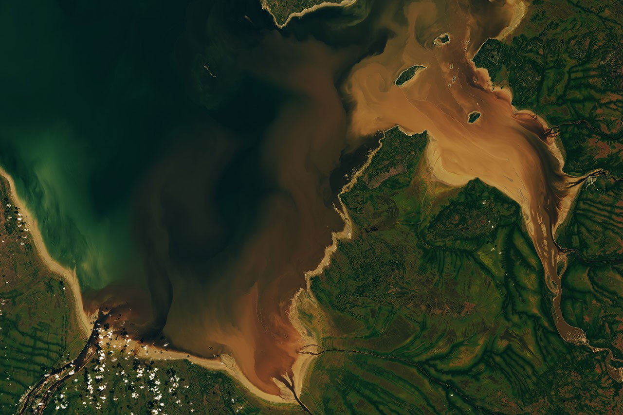
Landsat 9 imaged the Moose, Nottaway and Harricanaw rivers carrying tea-colored water into James Bay's southern bays on September 27, 2026. The stain is dissolved organic matter from boreal bog and forest. NASA's account gives no estimate of the carbon it carries.
The Scientist · Science desk
What happened
- The broad mudflats come from the bay's shallow, sloping floor, postglacial rebound lifting the land, and fine sediment the rivers keep depositing.
- NASA's account of the image does not report concentrations, river discharge or any estimate of the carbon the rivers deliver to James Bay.
- The Southern East Cree word pahtaaunaakun, meaning 'color of singed beaver', names the shade of the water.
Compiled by The ScientistSomething wrong?How this is made
Why it matters
- capability Because dissolved organic matter absorbs blue light, an optical imager such as OLI can follow where boreal river water spreads across the bays on a given day, the spatial half of any flux estimate.
- constraint Turning this scene into a carbon export figure would require ground measurements of concentration and river flow. A single color image contains neither.
- constraint Two kinds of brown share the river mouths, so any attempt to read dissolved carbon off this scene has to separate tea-colored water from stirred-up mud first.
On September 27, Landsat 9 recorded the color of the river water [1]. Colored dissolved organic matter, or CDOM, absorbs light in the blue and ultraviolet parts of the spectrum, so water carrying a lot of it looks brown [3]. The compounds include substances derived from tannins and lignins, which leach out of decaying leaves, roots, bark and soil, much as similar substances stain tea [4]. Here the supply is the boreal forest and boggy wetland the rivers cross in northern Quebec and Ontario before reaching Hannah and Rupert bays, the southernmost arms of James Bay [2].
There is a second brown in the scene. Tides and river currents stir up the mudflats and lift lighter brown plumes of suspended sediment that mix with the incoming river water [6]. Those plumes are particles of mud. Dissolved organic matter and suspended sediment both push the water toward brown, and in this image they meet at the river mouths [1][6]. The flats exist because the floor of southern James Bay is shallow and gently sloping, postglacial rebound is slowly lifting the land, and the rivers keep depositing fine mud [5].
NASA's account explains where the tea-colored water goes and why it has that color, but it does not report CDOM concentrations, river discharge or an estimate of the carbon delivered to the bay [13]. A flux needs both quantities: how much organic matter is in the water, and how much water passes. One frame from one day supplies neither, though it does show where boreal river water spread across the flats that day [1].
Onshore, NASA hedges too. It says differences in moisture and vegetation "likely" produce the green, veinlike branching: denser forest along stream channels shows dark green, while poorly drained peat bog with less tree cover shows lighter green [7].
The shade has a Cree name. Pahtaaunaakun means "color of singed beaver" in Southern East Cree [8]. European traders came to Rupert Bay for beaver as early as the 1660s. Their trade led to several posts on the bay's shores and to the founding of the Hudson's Bay Company [9]. In the 1830s, and again about a century later, in roughly the 1930s, the company and local Cree set up Charlton Island as a place to raise beavers for trapping [10][14]. Once predators were removed and breeding pairs delivered, the island's beaver population ballooned, according to historical accounts [10]. A Cree myth recorded by the anthropologist Alanson Skinner says Stag Rock, the island at the Nottaway's mouth, is a rock a giant hurled at a fleeing giant beaver, and missed [11].
The images are by Lauren Dauphin of NASA Earth Observatory, made with Landsat data from the U.S. Geological Survey; the story is by Adam Voiland [12].
What to watch
- Field sampling of CDOM concentration paired with discharge on the Moose, Nottaway and Harricanaw, which would put a carbon figure on what the image only shows.
- Later Landsat passes over Hannah and Rupert bays, which would show whether the September 27 plume extent is typical or a one-day snapshot.
Clarity's read
What the record supports and how the coverage leans. The claims behind it follow.
Reality
- Evidence55
- Adoption
- Insufficient
- Hype gap0
- Incentives
- Insufficient
- Confidence60
Claim ledger
Ranked by verification strength, evidence, and original report placement.
- [1]
The Operational Land Imager (OLI) on Landsat 9 captured an image on September 27, 2026, showing the Moose, Nottaway and Harricanaw rivers carrying tea-colored water across the broad mudflats of Hannah and Rupert bays and mingling with the darker blue waters of James Bay.
- [2]
Hannah Bay and Rupert Bay are the southernmost extensions of James Bay; the rivers and streams that flow into them wind through the boreal forests and boggy wetlands of northern Quebec and Ontario.
- [3]
Colored dissolved organic matter (CDOM) absorbs light in the blue and ultraviolet parts of the electromagnetic spectrum and causes water to appear brown.
- [4]
CDOM, including organic substances derived from tannins and lignins, leaches from decaying leaves, roots, bark and soils into streams and rivers; similar substances stain tea water brown.
- [5]
The mudflats along the shore are a product of the shallow, sloping bathymetry of southernmost James Bay; postglacial rebound is slowly lifting the landscape, and rivers continually deposit fine mud and other sediments that build up the flats.
- [6]
Tides and river currents often stir up the mud, producing lighter brown plumes of suspended sediment that mix with the incoming river water.
- [7]
Differences in moisture levels and vegetation patterns likely contribute to the green dendritic, veinlike patterns onshore; denser forested growth along stream channels appears dark green, while poorly drained peat bogs with less tree cover appear lighter green.
- [8]
The Cree word pahtaaunaakun means 'color of singed beaver' in Southern East Cree.
- [9]
European traders arrived in Rupert Bay as early as the 1660s to pursue beavers, leading to several trading posts along the bay's shores and the founding of the Hudson's Bay Company to cultivate the fur trade.
- [10]
The Hudson's Bay Company worked with local Cree people in the 1830s and again a century later to set up Charlton Island as a place to raise beavers for later trapping; after predators were removed and breeding pairs delivered, its beaver population ballooned, according to historical accounts.
- [11]
A Cree myth recorded by anthropologist Alanson Skinner tells of a giant pursuing an enormous beaver down the Nottaway River; the giant hurled a huge rock at it, missed, and created Stag Rock, the island in the river's mouth.
- [12]
The NASA Earth Observatory images are by Lauren Dauphin, using Landsat data from the U.S. Geological Survey; the story is by Adam Voiland.
- [13]
NASA Earth Observatory's account of the September 27 image describes the water colors and their causes; it does not report CDOM concentrations, river discharge, or an estimate of carbon delivered to James Bay.
- [14]
The second Charlton Island beaver-preserve effort came in roughly the 1930s.
Sources
1 independent publisher whose own reporting we read for this story.
- nasa.govThe Beaver Brown Waters of Rupert Bay
1 article · October 5, 2026
Topics and entities
Follow any of these and your For You feed starts watching them — no settings page required.
Topics
- Colored dissolved organic matterFollow
- Satellite Earth ObservationFollow
- Boreal peatlandsFollow
- North American fur tradeFollow