Science1 publisherNot yet confirmed elsewhere3 min readPublished
Central Pacific's Niño 3.4 region passes 30C for the first time as El Niño strengthens
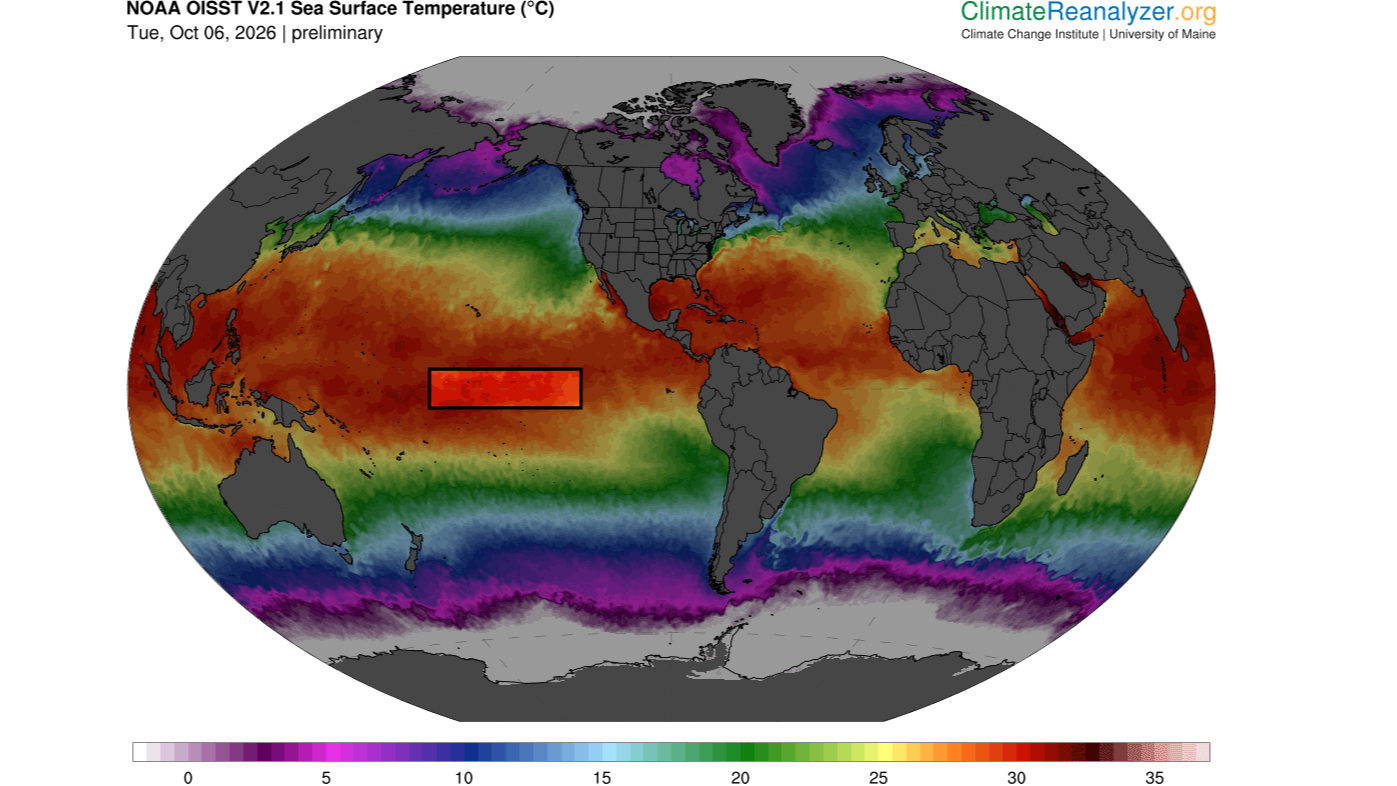
Sea surface temperatures in the Pacific's Niño 3.4 region passed 30 degrees Celsius for the first time, preliminary data released Oct. 5 show. On the anomaly measures that remove global ocean warming, the event is already close to the strongest El Niño on record, Timothy Osborn of the University of East Anglia told Live Science.
The Scientist · Science desk
What happened
- Waters above 30C are common this time of year in the western Pacific warm pool northeast of Australia, but Niño 3.4 lies far from it and is usually much cooler.
- Jin-Yi Yu of UC Irvine said the reading would be an extraordinary record if the daily value is verified in the observational dataset.
- Mat Collins of the University of Exeter expects Niño 3.4 temperatures to keep rising, peak in November or December, and decline in 2027.
Compiled by The ScientistSomething wrong?How this is made
Why it matters
- exposure A record-strength event would disrupt rainfall over the regions El Niño typically floods, including East Africa, southern China and the southern US, and those it dries, including Indonesia, the Philippines and southern Africa.
- precedent If the warming-adjusted index passes previous records, as Osborn expects, this event becomes the benchmark that any claim of a more extreme El Niño type will be tested against.
- constraint With the peak forecast for November or December, any strength ranking made now is provisional until the event tops out.
An absolute temperature is a poor way to rank an El Niño. Timothy Osborn, director of the Climatic Research Unit at the University of East Anglia, told Live Science that it is not the standard measure of strength [7]. Researchers compare Niño 3.4 with its own average conditions, or with sea surface temperatures across the rest of the tropics [7]. The second method is the control. It removes the skew that climate-driven heating of the oceans as a whole puts into the data [7].
That control matters this year. This El Niño is being amplified by human-driven warming that has raised background ocean temperatures [12]. A first 30C day in Niño 3.4 combines two signals: the event itself, and the warming of the ocean around it [7][12]. Jin-Yi Yu, a professor of Earth system science at the University of California, Irvine, said the data indicate "an exceptionally warm state for this part of the tropical Pacific" [2].
On the warming-adjusted measures, the event is still large. Osborn said that by those measures the event already nearly matches the strongest El Niño on record, and that he expects it to overtake earlier records soon because forecasts show it strengthening further [8]. "For some measures, it is already record-breaking for the time of year," he said [9]. Osborn and Mat Collins, head of mathematics and statistics at the University of Exeter, each called the reading "very significant" [4].
The anomaly gives the effect size. Measured against the top of the typical range, the current anomaly is 1.34C higher, about 1.7 times the usual upper limit [18][19]. "This indicates that a very strong, or what is sometimes called a 'super,' El Niño is developing," Yu said [11]. Forecasters have suggested the anomaly could reach 4C by November, 0.66C above the Oct. 6 value [17][20]. "The Niño 3.4 anomaly is very likely to remain extremely large and may increase further," Yu said [14].
Strength matters because of what it does to the atmosphere. "An El Nino with record strength is very significant because it greatly disrupts the atmospheric circulation which controls the weather patterns including patterns of rainfall," Osborn said [15].
Live Science framed the larger question as the world nears a critical warming threshold: whether conditions like these are a new normal for future El Niños [21]. The thing this doesn't tell you is whether the current event is a new type. One El Niño, however strong, is a single case. A new kind of event would have to show up as a pattern across many events on the warming-adjusted index. The measurements so far describe one event that has not yet peaked [13].
What to watch
- Whether the daily Niño 3.4 value above 30C is confirmed in the observational dataset, the condition Yu attached to calling it a record.
- Whether the Niño 3.4 anomaly reaches the 4C that forecasters have suggested for November.
- Whether the tropics-relative index, which removes background ocean warming, passes previous El Niño records as Osborn expects.
Clarity's read
What the record supports and how the coverage leans. The claims behind it follow.
Reality
- Evidence55
- Adoption
- Insufficient
- Hype gap+15
- Incentives
- Insufficient
- Confidence50
Claim ledger
Ranked by verification strength, evidence, and original report placement.
- [1]
Sea surface temperature in the Niño 3.4 region of the central equatorial Pacific exceeded 86 degrees Fahrenheit (30 degrees Celsius) for the first time on record, according to preliminary data released Monday, Oct. 5.
- [2]
an exceptionally warm state for this part of the tropical Pacific
ReportedSupportedSource: Jin-Yi Yu, professor of Earth system science, University of California, Irvine, to Live Science3 sources— create a free account to open themView cited source - [3]
If the reported daily El Niño 3.4 temperature above 30°C is verified in the observational dataset, it would be an extraordinary record
ReportedSupportedSource: Jin-Yi Yu, in an email to Live Science3 sources— create a free account to open themView cited source - [4]
Timothy Osborn called the Niño 3.4 reading above 86F a "very significant" new record, and Mat Collins, professor of climate systems and head of mathematics and statistics at the University of Exeter, also called the temperature "very significant".
ReportedSupportedSource: Osborn and Collins, emails to Live Science3 sources— create a free account to open themView cited source - [5]
The Niño 3.4 region lies between 5 degrees north and 5 degrees south latitude and between 120 and 170 degrees west longitude; researchers use it to monitor the progression of El Niño.
- [6]
Sea surface temperatures above 86F (30C) are common at this time of year in the western Pacific warm pool northeast of Australia, but the Niño 3.4 region is nowhere near the warm pool and usually has much cooler temperatures.
- [7]
Absolute temperature is not the standard way of measuring El Niño strength; researchers compare Niño 3.4 sea surface temperatures with the average conditions there or with sea surface temperatures across the rest of the tropics, the latter removing a skew caused by climate-change-induced heating of oceans globally.
ReportedSupportedSource: Timothy Osborn, director of the Climatic Research Unit, University of East Anglia, via Live ScienceView cited source - [8]
On those measures, the current event is already close to being the strongest [El Niño] on record and will likely soon exceed previous records given that the event is forecast to strengthen further
- [9]
For some measures, it is already record-breaking for the time of year.
- [10]
As of Oct. 6, the Niño 3.4 temperature anomaly was 3.34C (6F) above average and rising; a typical El Niño raises Niño 3.4 temperatures by a maximum of 1 to 2C above average.
- [11]
This indicates that a very strong, or what is sometimes called a 'super,' El Niño is developing.
- [12]
This year's El Niño is being amplified by human-driven global warming, which has increased background ocean temperatures.
- [13]
Sea surface temperatures in the Niño 3.4 region are likely to keep rising over the coming weeks and peak in November or December, before declining in 2027.
- [14]
The Niño 3.4 anomaly is very likely to remain extremely large and may increase further
- [15]
An El Nino with record strength is very significant because it greatly disrupts the atmospheric circulation which controls the weather patterns including patterns of rainfall.
- [16]
El Niño triggers heavy rainfall and floods in regions including East Africa, southern China, the southern U.S. and the Pacific coast of equatorial South America, while Indonesia, the Philippines, southern Africa and northern South America experience drought.
- [17]
Forecasters have suggested the Niño 3.4 anomaly could reach 4C (7.2F) by November.
- [18]
The Oct. 6 anomaly of 3.34C is 1.34C above the 2C top of the typical El Niño range.
- [19]
The Oct. 6 anomaly is about 1.7 times the upper end of the typical El Niño peak.
- [20]
Reaching the suggested 4C anomaly would require a further 0.66C over the Oct. 6 value.
- [21]
The world is on the brink of crossing a critical warming threshold, raising the question of whether current conditions can be considered a new normal for future El Niños.
Sources
1 independent publisher whose own reporting we read for this story.
Topics and entities
Follow any of these and your For You feed starts watching them — no settings page required.
Topics
Entities
- Live ScienceFollow
- Nino 3.4 regionFollow
- Timothy OsbornFollow
- Jin-Yi YuFollow
- Mat CollinsFollow
- Climatic Research UnitFollow
- University of ExeterFollow
- University of California, IrvineFollow