Science3 publishersIndependently confirmed3 min readPublished
WMO forecasts record Pacific warmth of 3.7C above normal as El Niño builds toward a December peak
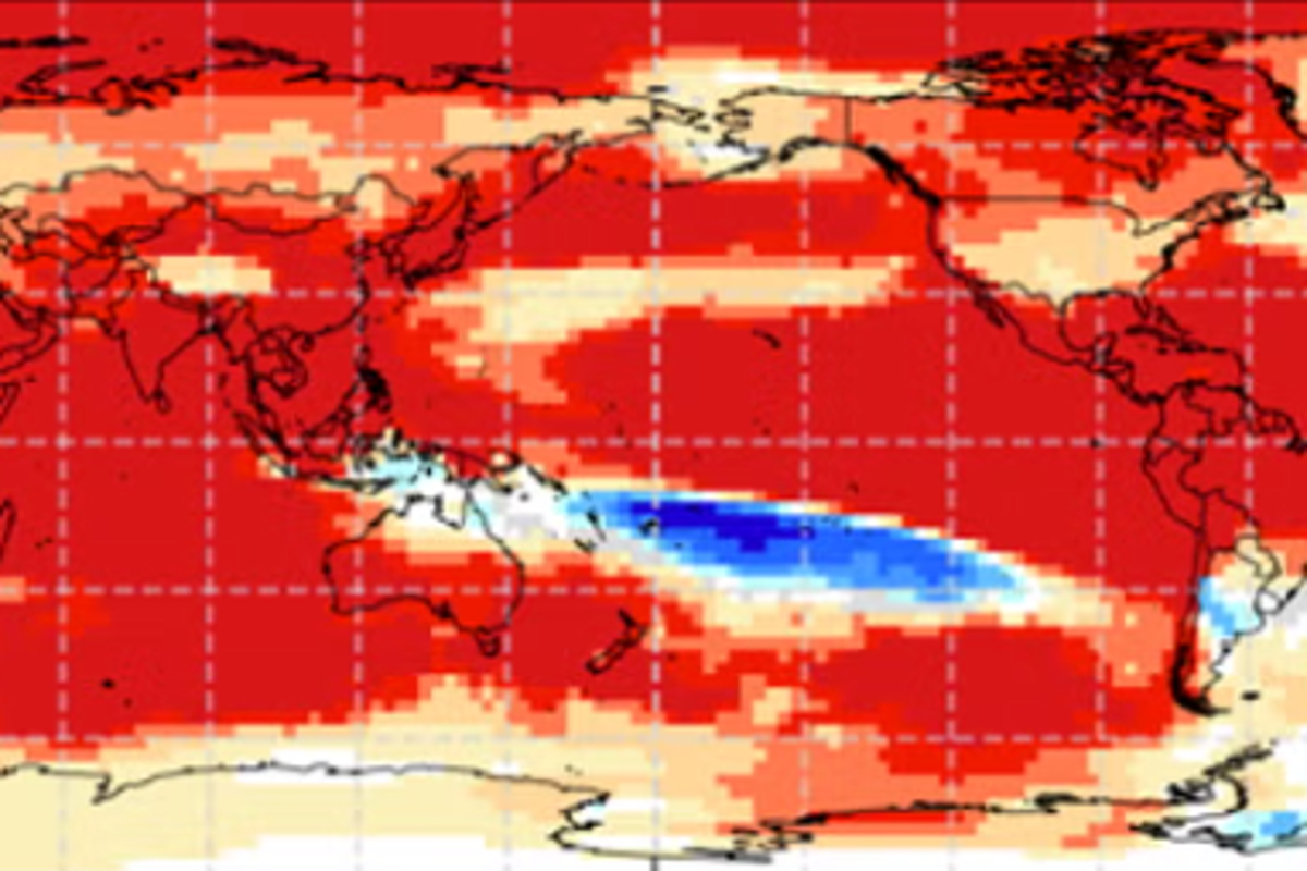
World Meteorological Organization forecasts put El Niño's peak around December and give it a near-100% chance of lasting through February 2027. Its maps tilt regional odds toward heat, drought or flood, and WMO says they do not replace local forecasts.
The Scientist · Science desk
What happened
- Niño 3.4, the index for the central-eastern equatorial Pacific, rose from +1.6C above normal in June to +2.5C in August.
- Copernicus put August's mean global temperature at 16.96C, tying July 2023 as the hottest month on record.
- India's southwest monsoon ended with a 13% rainfall deficit, its fourth driest season since 2001, according to the Indian Express.
Compiled by The ScientistSomething wrong?How this is made
Why it matters
- decision Persistence through February is the firmest part of the forecast, so winter planning can take the event as given and put its uncertainty into where regional impacts fall.
- constraint Site-level decisions on water, crops or heat cannot be read straight off WMO's global maps; they need national and local forecasts layered on top.
- exposure Indian states already rationing water go into October to December under a WMO signal for drier-than-normal conditions over the subcontinent.
WMO's record claim compares a forecast with an observation. The October-to-December anomaly is a predicted seasonal average. The November 2015-to-January 2016 mark it would replace was measured [4]. The two windows overlap by two months, and the forecast clears the old record by 1.1C [18]. An El Niño is declared once those waters run 0.5C above normal [17].
The observed climb points the same way. The Niño 3.4 index gained 0.9C between June and August [19]. Reaching the forecast seasonal mean would take roughly another 1.2C beyond the August reading [20].
The update expects the event to keep strengthening until its December peak [1]. According to WMO, the persistence probability is a consensus of 13 national and international centres working from shared ocean buoy, satellite and radiosonde data [11]. "El Niño is firmly established and strengthening rapidly. WMO forecasts indicate a nearly 100% likelihood that it will persist through February 2027, potentially being one of the strongest since at least 1950," WMO Secretary-General Celeste Saulo said [2]. Her wording is more careful than the index forecast. The sea surface anomaly is forecast to set a record, while the event as a whole is described as potentially one of the strongest since at least 1950.
Saulo gave the physical reason at the Global Heat Forum in Bangkok. "El Niño doesn't add new heat to the planet. It releases heat the ocean has already been storing beneath the surface," she said [5]. "The ocean it's drawing from is the warmest we've ever measured it. There is simply more heat available to release," she said [6]. Global sea surface temperature reached an all-time observed high in August [12].
The thing this update doesn't tell you is what any single site will see. Its rainfall signals mark where wetter or drier seasons are more likely, and WMO says they are not a substitute for national and local forecasts [13]. The temperature call is an overwhelming likelihood of above-average conditions across large areas, measured against a 1993-2009 baseline. That does not mean every place is warmer every day [7]. Wetter seasons are favoured in the Greater Horn of Africa, parts of Central Asia and coastal East Asia, the northern Arabian Peninsula, parts of North America south of 45 degrees north, and southeastern South America [14]. Drier ones are forecast for the Indian subcontinent and the western Pacific, with a dry band running across the South Pacific to the southern tip of South America [15]. A positive Indian Ocean Dipole, a pattern that can strongly influence rainfall around that ocean, is expected to peak in October and then decline [16].
In India, the dry outlook follows a monsoon that the Indian Express says El Niño weakened in its second half [8]. Maharashtra and Karnataka are among the states that have declared drought, and Maharashtra has imposed a 10% water cut in many of its districts [9].
I think the persistence forecast is firm enough to treat as a fixed condition through February. The regional maps are less firm. They shift odds over large areas, and a plan for one site needs the national service's outlook as well [13]. The only mortality estimate in these reports comes from the University of Chicago's Climate Impact Lab. Last month it projected as many as 451,000 excess deaths worldwide from June to February 2027, the Independent reported [21].
What to watch
- WMO's next monthly Global Seasonal Climate Update, and whether the October-December Niño 3.4 forecast holds near +3.7C.
- Observed Niño 3.4 readings for September and October, set against the climb from +1.6C in June to +2.5C in August.
- National post-monsoon forecasts for India, where WMO favours a drier October to December after drought declarations in Maharashtra and Karnataka.
Clarity's read
What the record supports and how the coverage leans. The claims behind it follow.
Reality
- Evidence72
- Adoption
- Insufficient
- Hype gap+8
- Incentives
- Insufficient
- Confidence68
Perspective Coverage
3 publishers- Builder
- Builder 28%
- Operator
- Operator 52%
- Investor
- Investor 20%
Claim ledger
Ranked by verification strength, evidence, and original report placement.
- [1]
WMO's monthly Global Seasonal Climate Update says El Niño will continue to intensify ahead of its forecast peak in December.
- [2]
"El Niño is firmly established and strengthening rapidly. WMO forecasts indicate a nearly 100% likelihood that it will persist through February 2027, potentially being one of the strongest since at least 1950," said WMO Secretary-General Celeste Saulo.
ReportedSupportedSource: Celeste Saulo, WMO Secretary-General3 sources— create a free account to open themView cited source - [3]
The Niño 3.4 index, measuring sea surface temperature anomalies in the central-eastern equatorial Pacific, rose from an average +1.6C above normal in June 2026 to +2.5C above normal in August.
- [4]
The October-December seasonal average Niño 3.4 anomaly is forecast at approximately +3.7C, peaking around December, the highest since observations began and above the previous record of +2.6C in November 2015-January 2016.
- [5]
"El Niño doesn't add new heat to the planet. It releases heat the ocean has already been storing beneath the surface," Saulo told the Global Heat Forum in Bangkok.
ReportedSupportedSource: Celeste Saulo, Global Heat Forum, Bangkok2 sources— create a free account to open themView cited source - [6]
"The ocean it's drawing from is the warmest we've ever measured it. There is simply more heat available to release," she said.
ReportedSupportedSource: Celeste Saulo2 sources— create a free account to open themView cited source - [7]
The update predicts an overwhelming likelihood of above-average (1993-2009 baseline) temperatures across large areas in October-December; this does not mean every location will be warmer than average every day.
- [8]
India's southwest monsoon ended with a 13% rainfall deficit, the fourth driest since 2001; El Niño impacted rainfall in the second half of the season.
ReportedSupportedSource: Indian Express2 sources— create a free account to open themView cited source - [9]
Many Indian states including Maharashtra and Karnataka have declared drought, and Maharashtra has imposed a 10% water cut in many of its districts.
ReportedSupportedSource: Indian Express2 sources— create a free account to open themView cited source - [10]
Mean global temperature in August reached 16.96C, tying July 2023 as the hottest month on record, according to the EU's Copernicus Climate Change Service.
ReportedSupportedSource: Copernicus, per the Independent2 sources— create a free account to open themView cited source - [11]
The near-certainty figure is a consensus across 13 national and international centres, built on real-time exchange of ocean buoy, satellite and radiosonde data coordinated by WMO.
- [12]
Global sea surface temperature reached an all-time observed high in August.
- [13]
The rainfall signals describe where wetter- or drier-than-normal seasonal conditions are more likely and are not a substitute for national and local forecasts.
- [14]
Wetter-than-normal conditions are more likely across the Greater Horn of Africa, parts of Central Asia and coastal East Asia, northern parts of the Arabian Peninsula, parts of North America south of 45N, and southeastern South America.
- [15]
A broad dry signal is forecast over the western Pacific and equatorial Atlantic, stretching across the South Pacific to the southern tip of South America; drier-than-normal conditions are forecast over the Indian subcontinent.
- [16]
A positive Indian Ocean Dipole, which can strongly influence rainfall around the Indian Ocean, is expected to peak in October and then decline, with an October-December anomaly of about +0.5C.
- [17]
El Niño is declared when sea temperatures along the equatorial and central Pacific exceed 0.5C above normal.
- [18]
The forecast Oct-Dec Niño 3.4 anomaly exceeds the previous record by 1.1C.
- [19]
The Niño 3.4 anomaly rose 0.9C between June and August 2026.
- [20]
Reaching the forecast Oct-Dec mean requires about 1.2C more warming beyond the August anomaly.
- [21]
Researchers at the University of Chicago's Climate Impact Lab predicted last month that this year's El Niño was likely to result in as many as 451,000 excess deaths globally from June to February 2027.
Sources
3 independent publishers whose own reporting we read for this story.
- independent.co.ukUN weather body provides update on when El Nino will peak – and end
1 article · October 8, 2026
- indianexpress.comWorst of El Niño yet to come, peak likely in December
1 article · October 8, 2026
- phys.orgSea surface temperatures suggest El Niño is strengthening
1 article · October 8, 2026
Topics and entities
Follow any of these and your For You feed starts watching them — no settings page required.
Topics
Entities
- Indian Ocean DipoleFollow
- Niño 3.4 indexFollow
- Celeste SauloFollow
- Climate Impact LabFollow
- World Meteorological OrganizationFollow
- Copernicus Climate Change ServiceFollow