Science1 publisherNot yet confirmed elsewhere3 min readPublished
A 3.9C El Nino peak makes 2027 a stress test for plans built for the late 2030s
Forecasters see this El Nino peaking well above the 2015 event and pushing 2027 to roughly 1.76C above preindustrial. That is a decade of trend warming delivered in one year.
The Scientist · Science desk
Drafted by a language model from the sources cited here and checked against its claim ledger before publication. How we use AISend a correction
What happened
- This year's El Nino is on track to be the strongest on record, threatening extreme weather across the globe and making 2027 the hottest recorded year by far.
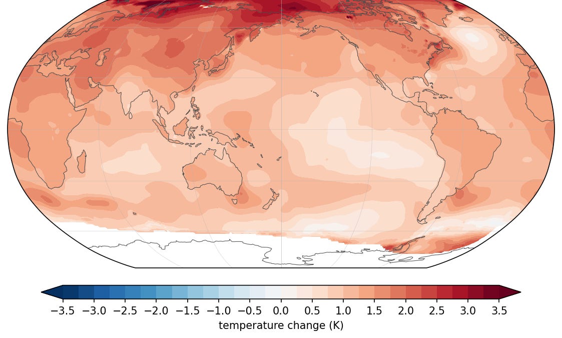
- Stacked on top of long-term human-caused climate change, the temporary jolt will offer a glimpse of the heat the world can expect by the late 2030s, experts say.
- Daily sea surface temperatures in the Nino 3.4 region are currently running about 2.6C above a rolling 30-year average, according to the Climate Brink dashboard, which draws on NOAA's satellite-and-buoy sea surface record.
- The Climate Brink dashboard aggregates forecasts that put El Nino on course to peak at a 3.9C anomaly this November, well above the 3C anomaly detected in the 2015 El Nino.
- The event makes this year a contender for hottest year on record, currently held by 2024, and makes 2027 a near certainty for the top spot, since most of the heat impact is felt the following year.
Compiled by The ScientistSomething wrong?How this is made
Why it matters
Forecasters have this year's El Nino on course to be the strongest on record, with aggregated projections pointing to a peak Nino 3.4 anomaly of 3.9C in November [3][5]. Because most of an El Nino's heat lands the following year, 2027 is close to a certainty for the hottest year on record, and on published estimates it arrives about a decade ahead of the underlying warming curve [6][7][20].
The mechanism is not exotic. Trade winds that blow east to west ease, and warm water that normally piles up in the western Pacific slides back east and rises to the surface [12]. When those warmer-than-average surface temperatures persist for months they drive more storms and cloud over the region, which Emily Becker of the University of Miami describes as causing ripple effects through the entire global atmosphere [12]. The output is hotter and drier conditions in some places, cooler and wetter in others [13].
The numbers: daily sea surface temperatures in the Nino 3.4 box are running about 2.6C above a rolling 30-year average, according to the Climate Brink dashboard, which draws on NOAA's satellite-and-buoy record [4]. The forecast 3.9C peak would be 0.9C above the 3C anomaly detected in the 2015 event, roughly 30 percent larger on that index [5][17]. Measurement is not settled: NOAA adopted the Relative Oceanic Niño Index in February, which scores Nino 3.4 warming against the whole tropical belt [9]. On that scale the values are lower but the ranking holds, and NOAA puts the odds at 69 percent that this is the strongest event in its dataset back to 1950 [10].
For planning, the arithmetic that matters comes from Zeke Hausfather and Andrew Dessler, who calculate the event adds a temporary 0.3C on top of the long-term trend, giving 2027 a global temperature of 1.76C above preindustrial and compressing into one year as much warming as would otherwise be expected by 2037 [7]. That implies a background trend near 1.46C with the El Nino spike removed [18]. NOAA's Mike McPhaden reached a similar figure independently, telling AFP it is not inconceivable 2027 tops out at 1.7C if model forecasts bear out, a spread of 0.06C between the two estimates [8][19]. Anyone whose 2027 assumptions for reservoir inflow, irrigation demand, peak cooling load or fire season length are anchored to a trend line is working from a line that is ten years stale for that one year [20].
Two caveats are load-bearing. Dessler calls it a preview of the future but notes much of the heat is focused in the equatorial Pacific, so this is not a uniform global dress rehearsal [2]. And Michelle L'Heureux, ENSO team lead at NOAA's Climate Prediction Center, told AFP that stronger events mean more of the expected El Nino impacts, while cautioning that none are guaranteed [11]. Some are already arriving: Indonesia's long, intense dry season has fed wildfires that have burned hundreds of thousands of hectares [14]. Warming loads both tails, since a moister atmosphere makes El Nino-linked rains more extreme while drier soils deepen drought where El Nino brings it [15].
Watch the November peak against the 3.9C forecast, and whether the RONI ranking confirms NOAA's 69 percent [5][10]. Watch too the amplitude question: McPhaden says coral records, instrument readings back to the 19th century and modeling all suggest El Nino events may have grown about 10 percent stronger over the past century, though there is less consensus on whether climate change is triggering stronger events at all [16][21].