Science2 publishersIndependently confirmed3 min readPublished
El Nino at 3.9C: the Met Office puts the heat record in 2027, and the warning arrives now
The Met Office expects the tropical Pacific above 3C in November, and one aggregated forecast says 3.9C. The global temperature consequence lands in 2027, which is still a planning cycle away.
The Scientist · Science desk
Drafted by a language model from the sources cited here and checked against its claim ledger before publication. How we use AISend a correction
What happened
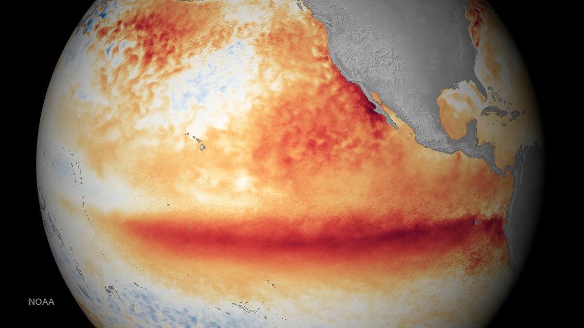
- The Met Office says this El Nino will be the biggest in more than a century, peaking at something over 3C in the tropical Pacific.
- Met Office scientist Nick Dunstone says 2027 is very likely to replace 2024 as the warmest year on record.
- The event has already fed Hurricane Lala, which flooded Hawaii, while suppressing Atlantic hurricane activity, Scientific American reports.
Compiled by The ScientistSomething wrong?How this is made
Why it matters
- decision 2027 budgets and hedges are being written against last year's normals while the forecaster has already withdrawn that baseline; the choice of which number to model is live now, not after the peak...
- exposure Splitting catastrophe exposure between the Atlantic and the Pacific buys less protection in a strong El Nino year, because one basin is quiet for the same reason the other is busy.
- constraint The drought map is published months ahead, but a growing season cannot be rescheduled, so exposed regions can price a shortfall and little else.
- precedent Another temporary breach of 1.5C so soon after the last one turns exceedance into the expected annual condition rather than the exception the target implied.
The useful part of this forecast is the calendar rather than the peak. The event was declared in early June and is expected to top out in November [7][8], about five months from declaration to maximum [26], and the global temperature consequence lands the year after, because the heat released from the Pacific reaches the atmosphere on a delay [4]. That is why the Met Office's Nick Dunstone points at 2027 rather than 2026 for the record [3]. Physical inputs rarely announce themselves that far ahead of the invoice.
The distance still to travel is worth stating in plain numbers. The Pacific is running about 2.6C above a rolling 30-year average on the Climate Brink dashboard, which uses NOAA data [2], while the forecasts that dashboard aggregates put the November peak at 3.9C [8]. That is a further 1.3C in roughly a quarter [23]. An El Nino is declared at 0.5C above baseline [9], so a 3.9C peak would sit close to eight times the definitional threshold [24] and 0.9C above the 3C recorded in 2015 [25]. Adam Scaife, who runs long-range forecasting at the Met Office, puts a typical event at 1C to 2C and calls 2C already a really big one [13]; the current reading has passed that mark by 0.6C with months of warming still in the forecast [22].
There is a real spread inside the reporting, and it is not decorative. Scaife told the BBC to expect something over 3C [1]. The aggregate says 3.9C [8]. The 0.9C between those two figures is nearly twice the anomaly needed to call an El Nino at all [21], and the two ends of that range do not imply the same losses for anyone buying cover or grain forward.
The regional signature is the part already usable. El Nino reliably dries Southeast Asia, Australia, southern Africa and northern Brazil while wetting the Horn of Africa, the southern United States, Peru and Ecuador [14]. Scaife expects severe drought in South America and the West Pacific [15], and increased rainfall and storminess in the United Kingdom around November [16]. His framing matters more than any single region: these are long-term persistent conditions, not a short-term weather forecast [18].
One caution against filing 2027 as an outlier. Both 1998 and 2016 were records when they happened, and both have since dropped down the rankings as warming makes record heat more likely [12]. Last year finished third [11]. An El Nino record is a spike riding a rising line, which means the year the Met Office expects to break the record is a reasonable preview of an ordinary year later in the decade, not a number to smooth out of a baseline. Scaife calls the event unprecedented and says he has never seen a signal this intense in the model output [6]; that is a statement about the forecast, and the observed peak in November is what will test it.
What to watch
- Whether Copernicus and NOAA move their own annual outlooks into line with the Met Office's record call for 2027, or hold a wider range.
- Southern African and Australian rainfall through the coming season, the first place a forecast drought becomes a measured shortfall.
- Whether Atlantic hurricane suppression holds for the rest of the season while Pacific activity stays elevated.