ScienceIndependently confirmed2 publishers2 min readPublished
Isaias, the Atlantic's first hurricane of a late season, strikes Florida's panhandle as a Category 2
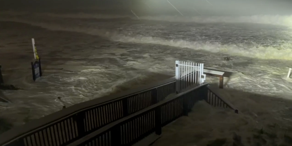
Hurricane Isaias made landfall on Florida's western panhandle on Friday evening as a Category 2 storm with 110 mph winds. It is the first Atlantic hurricane of a season the BBC says El Nino delayed until October, a late start not seen in more than 30 years.
The Scientist · Science desk
What happened
- The National Hurricane Center warned of life-threatening storm surge on the Gulf Coast, with flooding of up to 9 feet possible in some areas.
- Florida, Alabama and Georgia declared states of emergency, and Florida and Alabama ordered mandatory evacuations.
- Two other storm systems were hitting Mexico and Southern California from warm Pacific waters that the BBC describes as El Nino-fuelled.
- The National Weather Service forecast the centre of Isaias to cross Alabama and move into the Tennessee Valley on Saturday and Sunday.
Why it matters
- exposure Inland Alabama, Georgia and the Tennessee Valley lie on the forecast path and inside the outer wind field, far from the coastal communities that Florida's evacuation orders cover.
- constraint People who stayed depend on receiving tornado and surge warnings, and outages that began before landfall cut into the ways those warnings can reach them.
- decision Alabama's mandatory order covers non-residents, tourists and visitors in key counties, so residents there are deciding for themselves whether to ride out the storm.
The Category 2 rating and its 110 mph winds describe Isaias near its centre [1]. The wind field is wider. As of Friday evening, hurricane-force winds extended up to 35 miles from the centre and tropical-storm-force winds as far as 205 miles [10]. The outer radius is nearly six times the inner one [18]. Both figures are stated as maximum extents, so they bound the field without describing its shape. Georgia, away from the landfall coast, was expecting weaker winds further inland and already had about 8,000 customers without power [9].
The outage counts were taken before Isaias reached land. PowerOutage.us counted more than 350,000 in Florida and 170,000 in Alabama [8]. Adding Georgia gives at least 528,000 [17]. The Georgia figure is given in customers, and we'd read the total the same way, as connections without power.
Isaias is also late. According to the BBC, the Atlantic season has largely been delayed by El Nino conditions in the Pacific, and this is the first time in more than 30 years that a hurricane did not form until October [2] [3]. The same report places the two Pacific storms in El Nino-fuelled warm waters [12]. So one climate pattern gets the credit for holding back one ocean's storms and feeding the other's. That attribution is the BBC's. In our view a single late season fits it, but cannot measure how much of the delay El Nino caused.
On this evidence, Isaias and the Pacific systems overlap in timing. The BBC report does not describe crews, shelters or supplies being shared between states or running short, and it covers the Pacific storms in a single sentence [12].
Officials pressed people to go. Florida Senator Rick Scott wrote in a social media post: "DO NOT WAIT! Get out NOW!" [7] Melissa Watson, a Florida-based National Weather Service meteorologist, warned of possible tornadoes. She told the BBC that for those who have not evacuated, "the main thing will be having multiple ways to receive warnings" [15]. She added: "We want people to remain inside and safe while the hurricane is moving through." [16]
Some stayed anyway. John Guoth of Navarre said the rest of his street had left, but he and his wife were staying at home [13]. "It's a hurricane, we get them all the time... we kind of knew that when we moved here," he said [13]. In Pensacola, Brandin Ruth said: "You don't want to underestimate a storm like this" [14].
What to watch
- Outage counts once the centre has crossed Alabama into the Tennessee Valley over the weekend, compared with the pre-landfall tallies.
- Measured surge heights along the panhandle coast against the National Hurricane Center's forecast.
- Reporting from Mexico and Southern California on the two Pacific systems, which would show whether response demands actually overlap.
Clarity's read
What the record supports and how the coverage leans. The claims behind it follow.
Reality
- Evidence72
- Adoption
- Insufficient
- Hype gap+5
- Incentives
- Insufficient
- Confidence68
Claim ledger
Ranked by verification strength, evidence, and original report placement.
- [1]
Hurricane Isaias weakened slightly to a Category 2 hurricane with 110 mph winds before making landfall in Florida's western panhandle on Friday evening.
- [2]
Isaias is the first hurricane of the Atlantic hurricane season, which the BBC says has largely been delayed due to El Nino conditions in the Pacific.
- [3]
It is the first time in more than 30 years that a hurricane did not form until October.
- [4]
The National Hurricane Center warned of 'life-threatening storm surge' on the US Gulf Coast; meteorologists warned surge could cause up to 9 feet of flooding in some areas.
ReportedSupportedSource: National Hurricane Center, via BBC2 sources— create a free account to open themView cited source - [5]
Florida, Alabama and Georgia each issued states of emergency, and Florida and Alabama instituted mandatory evacuations.
- [6]
Alabama Governor Kay Ivey issued a mandatory evacuation for all non-residents, tourists and visitors in key counties likely to be heavily affected.
- [7]
Florida Senator Rick Scott wrote in a social media post: "DO NOT WAIT! Get out NOW!"
ReportedSupportedSource: Rick Scott, via BBC2 sources— create a free account to open themView cited source - [8]
Before landfall, more than 350,000 were without power in Florida and another 170,000 in Alabama, according to PowerOutage.us.
ReportedSupportedSource: PowerOutage.us, via BBC2 sources— create a free account to open themView cited source - [9]
The hurricane's winds were expected further inland in Georgia at lesser intensity, where about 8,000 customers were already without power.
- [10]
As of Friday evening, hurricane-force winds extended outward up to 35 miles from Isaias' centre and tropical storm-force winds as far as 205 miles.
- [11]
The National Weather Service said the centre of Isaias is forecast to move across Alabama and into the Tennessee Valley on Saturday and Sunday.
ReportedSupportedSource: National Weather Service, via BBC2 sources— create a free account to open themView cited source - [12]
Isaias is one of three storm systems affecting North America this weekend; the other two are hitting Mexico and Southern California in the El Nino-fuelled warm waters of the Pacific.
- [13]
John Guoth of Navarre, Florida, said he and his wife would remain at home though the rest of his street had left: "It's a hurricane, we get them all the time... we kind of knew that when we moved here,"
ReportedSupportedSource: John Guoth, via BBC2 sources— create a free account to open themView cited source - [14]
Pensacola resident Brandin Ruth said: "You don't want to underestimate a storm like this"
ReportedSupportedSource: Brandin Ruth, via BBC2 sources— create a free account to open themView cited source - [15]
Melissa Watson, a Florida-based National Weather Service meteorologist, told the BBC there is potential for tornadoes and that for those who have not evacuated, "the main thing will be having multiple ways to receive warnings" about tornadoes and storm surges.
- [16]
"We want people to remain inside and safe while the hurricane is moving through."
- [17]
Pre-landfall outages across Florida, Alabama and Georgia totalled at least about 528,000.
- [18]
The tropical-storm-force wind radius was nearly six times the hurricane-force radius.
Sources
2 independent publishers whose own reporting we read for this story.
- bbc.co.ukLife-threatening Hurricane Isaias makes landfall in Florida
1 article · October 9, 2026
- phys.orgIsaias downgraded to post-tropical cyclone after landfall in Florida
1 article · October 10, 2026
Topics and entities
Follow any of these and your For You feed starts watching them — no settings page required.
Entities
- Rick ScottFollow
- National Weather ServiceFollow
- AFPFollow
- Ron DeSantisFollow
- PowerOutage.usFollow
- BBCFollow
- Climate CentralFollow
- Hurricane Isaias (2026)Follow
- Kay IveyFollow
- National Hurricane CenterFollow