Science1 publisherNot yet confirmed elsewhere2 min readPublished
Penn State team adapts image-generator diffusion to forecast flash floods by the hour
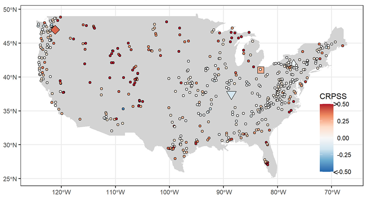
Penn State researchers trained a diffusion model, the method behind AI image generators, on more than 500 US river basins to forecast hourly flash-flood risk. It takes in new gauge readings without retraining, so a warning service could keep it current.
The Scientist · Science desk
What happened
- The model learned from rainfall and streamflow records collected across the continental US between 1990 and 2003.
- Shen's group's earlier national-scale models worked well on historical data but struggled to capture the rapid swings that drive flash floods.
- The model puts an uncertainty estimate on its predictions and tightens it using recent gauge observations.
- The work appeared in Water Resources Research, with Penn State engineering professor Chaopeng Shen as corresponding author.
- Flash floods make up roughly 85% of floods and kill thousands of people a year worldwide, according to the National Weather Service.
Compiled by The ScientistSomething wrong?How this is made
Why it matters
- capability Correcting a forecast with the latest gauge data costs a model run instead of a retraining job, so updates can keep pace with incoming observations.
- constraint The training record ends in 2003, 22 years before the Central Texas flood, so the model's skill on recent storms has to be checked against later years before a forecaster relies on it.
- decision An uncertainty range lets a warning office set its own alert threshold instead of acting on a single predicted peak.
Shen explains the method with a picture that has a piece missing. It is like handing a model an image or a sentence with a portion cut out and asking it to predict what belongs in the gap, he said [9]. Diffusion is the training method most often used in image generation. It starts from a complete data set, adds noise, and asks the model to remove the noise and reproduce the original [10].
Shen said the approach suits flood forecasting because rainfall can be highly unpredictable from one hour to the next [11]. A model trained to recover a signal from corrupted input has practised on bad data by design. The same fill-in step is how fresh observations reach it: recent gauge readings are assimilated into the data set without retraining, a process known as inpainting [12]. "Your basic training inputs include the hourly rainfall, your projected streamflow, all this data that is collected from previous patterns," Shen said [14].
The case for an hourly step is also Shen's. "We've previously delivered a daily flood forecasting model, but it's widely understood that the peaks of flash floods occur at an hourly scale," he said [8]. He added: "Water levels can rapidly rise and recede in just a matter of hours, meaning on a daily scale, they might still seem high, but not disaster-inducing." [15] The Central Texas flooding of summer 2025 rose and fell within hours [7].
The thing this account doesn't tell you is how large the gain is. It says the model forms accurate predictions from unreliable weather data [1]. It does not include error statistics, a peak-by-peak comparison with the team's daily model, or the years held out for testing. Those are the figures that would show whether hourly calibration catches the peaks a daily model smooths away.
I think the update path matters more to an operating forecast service than any single accuracy score, provided the paper's figures hold up. A forecaster's practical bottleneck is keeping a model current as gauges report. Shen set the change against older practice. "Before the age of AI, scientists had to manually assimilate data, using a lot of assumptions and mathematical gymnastics to make predictions," he said [16].
What to watch
- Peak-flow error statistics in the Water Resources Research paper, set against the team's daily model.
- Tests on storms after 2003, including the summer 2025 Central Texas flooding, if the team runs them.
- Whether the National Weather Service or another forecasting agency trials the model on live gauge feeds.
Clarity's read
What the record supports and how the coverage leans. The claims behind it follow.
Reality
- Evidence45
- Adoption
- Insufficient
- Hype gap+30
- Incentives
- Insufficient
- Confidence40
Claim ledger
Ranked by verification strength, evidence, and original report placement.
- [1]
The team demonstrated that the model can parse notoriously unreliable weather data to form accurate predictions and can be easily updated with new data from water monitoring gauges.
ReportedSupportedSource: phys.org account of the team's paper2 sources— create a free account to open themView cited source - [2]
According to the National Weather Service, flash floods account for roughly 85% of floods and cause thousands of deaths annually worldwide, with water levels able to rise 30 feet (9 meters) and recede within a single day.
- [3]
A team of scientists including Penn State researchers applied the techniques behind AI image generation to predict hourly flash flood risk.
- [4]
The model was trained on rainfall and streamflow data collected from over 500 river basins across the continental U.S. between 1990 and 2003.
- [5]
The approach was published in Water Resources Research; Chaopeng Shen, professor of civil and environmental engineering at Penn State, is corresponding author.
- [6]
Shen's team's earlier national-scale models make accurate predictions from historical rainfall and streamflow but have trouble capturing the severity of rapid weather swings that lead to flash floods.
- [7]
The flooding that swept across Central Texas in the summer of 2025 swelled and receded in a matter of hours.
- [8]
"We've previously delivered a daily flood forecasting model, but it's widely understood that the peaks of flash floods occur at an hourly scale,"
- [9]
Shen said the process is like giving a model an image or a sentence with a portion missing and asking it to predict content in that unknown region.
- [10]
The model uses diffusion, a training method most commonly used in image generation, in which a model receives a complete data set, noise is introduced, and the model is asked to remove the noise and reproduce an interpretable data set.
- [11]
Shen said the diffusion approach is particularly effective for flood prediction because rainfall can be incredibly unpredictable on an hourly basis.
- [12]
Recent gauge observations can be assimilated into the model without retraining, a process known as inpainting.
- [13]
The model can quantify uncertainty in its predictions, reducing doubts by assimilating recent gauge observations into the data set.
- [14]
"Your basic training inputs include the hourly rainfall, your projected streamflow, all this data that is collected from previous patterns,"
- [15]
"Water levels can rapidly rise and recede in just a matter of hours, meaning on a daily scale, they might still seem high, but not disaster-inducing."
- [16]
"Before the age of AI, scientists had to manually assimilate data, using a lot of assumptions and mathematical gymnastics to make predictions,"
- [17]
The training record ends 22 years before the summer 2025 Central Texas flooding.
Sources
1 independent publisher whose own reporting we read for this story.
- phys.orgAI techniques behind image creation improve flash flood forecasts across U.S. river basins
1 article · October 6, 2026
Topics and entities
Follow any of these and your For You feed starts watching them — no settings page required.
Topics
- Machine learning in hydrologyFollow
- Diffusion Model InferenceFollow
- Flash flood forecastingFollow
Entities
- Penn StateFollow
- Chaopeng ShenFollow
- Water Resources ResearchFollow
- National Weather ServiceFollow