Dedicated methane satellites caught 92% to 100% of test plumes in a controlled Arizona trial
Stanford researchers report in Nature that dedicated methane satellites detected 92% to 100% of test plumes in 481 releases at one Arizona site. The rates apply to clear days at a desert site, and most size estimates were off by up to 50%.
The Scientist · Science desk
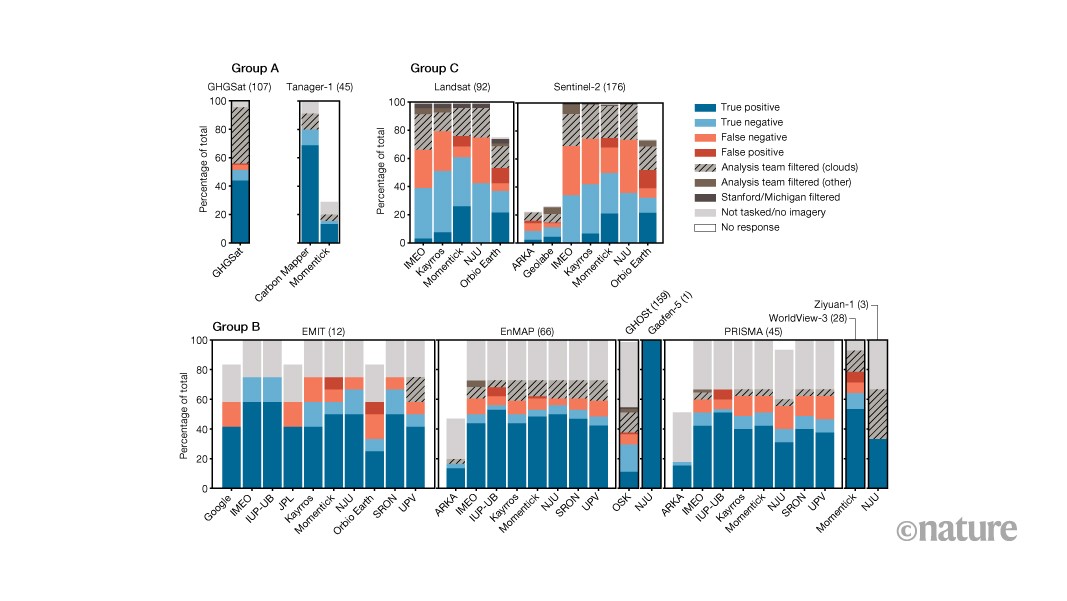
Dedicated methane instruments detected at least 92% of test plumes, up to 100%. Repurposed instruments such as Germany's EnMAP detected at least 62%, up to 88%, when skies were clear. General-purpose land-scanning systems detected at least 29%, up to 37%.
| Figure | Value | Note | Claim |
|---|---|---|---|
| Dedicated methane instruments, at least | 92% of test plumes | up to 100% | 5 |
| Repurposed instruments, clear skies, at least | 62% of plumes | up to 88% | 14 |
| General-purpose land-scanning systems, at least | 29% of plumes | up to 37% | 15 |
What happened
- Fifteen research teams across nine countries analyzed the satellite observations independently, judging whether each image showed a plume and how much methane was released.
- Under few clouds and moderate wind, the dedicated instruments reliably detected plumes down to about 50 to 200 kilograms per hour, depending on the system.
- Instruments repurposed for methane sensing, such as Germany's EnMAP, detected 62% to 88% of plumes when skies over the test site were clear.
- General-purpose land-scanning satellites detected 29% to 37% of plumes and were especially error-prone for releases below 1,000 kilograms per hour.
Why it matters
- decision Some super-emitter programs trigger reviews at 100 kilograms per hour, so a regulator choosing a satellite has to check that system's limit; the least sensitive dedicated one reliably sees about twice that.
- constraint The detection rates describe clear days. A monitoring program that relies on satellites alone should expect gaps whenever cloud cover is heavy.
- capability With size estimates balanced around the true value on average, governments and operators can use satellite data to flag large leaks and compare oil and gas regions, the authors said.
The study is pitched as a benchmark for systems that regulators, environmental groups and companies increasingly use [2]. Its conditions are narrow: one desert site in Casa Grande [3], clear skies and moderate wind [8].
The 92% to 100% range covers the dedicated instruments as a group [5]. The phys.org account does not say how many of the 481 releases each satellite actually overflew, so the denominator behind each end of the range is not visible. The gap to the general-purpose land-scanning systems is at least 55 percentage points, the 92 at the bottom of the dedicated range minus the 37 at the top of theirs [21].
The test also checked for false alarms. The authors gave analytics teams observations from 265 overpasses when no methane was released [17], because false positives can reduce public trust and waste resources on efforts to address nonexistent leaks [18].
Size is looser than presence. Most estimates were up to 50% above or below the actual release, though the errors roughly balanced out on average [6]. Senior author Adam Brandt, a Stanford professor, put the practical consequence this way: "In many cases, the detection is the important part," he said. "As long as you know approximately how big it is, then you still know you need to go fix it." [10] For a rule that triggers at a fixed threshold, the error matters more: a true 100 kilogram-per-hour leak estimated 50% off could be reported anywhere from 50 to 150 [19].
Clouds are the largest gap between this test and a production deployment. The instruments detect methane using infrared light reflected off Earth's surface, and even the dedicated instruments aboard GHGSat and Tanager-1 struggled to see plumes through clouds [11]. "This poses problems in some key methane-emitting regions," the authors write, "including tropical oil and gas producers Nigeria and Venezuela, as well as cold, cloudy climates like Canada and Russia." [12]
The test does not show whether the rates hold on other terrain. The authors said more research is needed on nondesert terrain, across various weather conditions and over open water [13].
The weaker systems keep a role. The land-scanning instruments gather less of the spectral data needed to isolate methane's signature, but the researchers said their extensive coverage and historical archives remain valuable for documenting long-term trends and identifying large leaks [16].
What to watch
- Per-system false-positive rates from the 265 no-release overpasses in the Nature paper.
- Follow-up releases over nondesert terrain, cloudier weather and open water, which the authors say are needed.
- Whether super-emitter programs that trigger at 100 kilograms per hour start writing satellite detection limits into their rules.
Clarity's read
What the record supports and how the coverage leans. The claims behind it follow.
Reality
- Evidence72
- Adoption
- Insufficient
- Hype gap+15
- Incentives
- Insufficient
- Confidence65
Claim ledger
Ranked by verification strength, evidence, and original report placement.
- [1]
Researchers conducted the largest-ever controlled test of space-based methane monitoring, finding that dedicated methane sensors correctly detected nearly all methane plumes released on clear days.
- [2]
The results were published Oct. 14 in Nature and provide a benchmark for satellite systems increasingly used by regulators, environmental groups and companies to detect leaks and identify super-emitters.
- [3]
Brandt, lead author Frances Reuland and collaborators timed 481 methane releases at a Stanford research site in Casa Grande, Arizona, to overpasses by 11 government, nonprofit and commercial satellites throughout 2025.
- [4]
Fifteen research teams from corporations, nonprofits, government agencies and academia across nine countries independently analyzed the observations, assessing whether each image showed a methane plume and, if so, how much methane was released.
- [5]
Instruments designed specifically for methane monitoring produced the best detection rates, correctly identifying the presence of 92%-100% of test plumes.
- [6]
Most estimates of release size were up to 50% higher or lower than actual emission amounts, but the over- and underestimates roughly balanced out on average.
- [7]
The authors said the estimates are reliable enough to flag large leaks for follow-up, inform governments' regional greenhouse gas inventories and assess the relative emissions intensity of different oil and gas regions.
- [8]
Under ideal conditions, with few clouds and moderate wind, the dedicated instruments reliably detected plumes when methane flowed at rates down to about 50-200 kilograms per hour, depending on the system.
- [9]
The 50-200 kilograms per hour detection range is close to the 100 kilograms per hour threshold that triggers reviews under some state and national super-emitter programs.
- [10]
Adam Brandt, senior author and Stanford professor, said: "In many cases, the detection is the important part. As long as you know approximately how big it is, then you still know you need to go fix it."
- [11]
Satellite methane detection uses infrared light reflected off Earth's surface, and even the dedicated instruments aboard GHGSat and Tanager-1 satellites struggled to detect plumes through clouds.
- [12]
The authors write: "This poses problems in some key methane-emitting regions, including tropical oil and gas producers Nigeria and Venezuela, as well as cold, cloudy climates like Canada and Russia."
- [13]
The authors said more research is needed to understand how these satellite systems and algorithms work over nondesert terrain, across various weather conditions and over open water.
- [14]
Instruments repurposed for methane sensing, such as Germany's EnMAP, detected 62%-88% of methane plumes when skies over the test site were clear.
- [15]
General-purpose land-scanning systems aboard U.S. and European government satellites detected just 29%-37% of plumes and were especially error-prone for releases below 1,000 kilograms per hour.
- [16]
Land-scanning systems gather less of the spectral data required to isolate methane's signature, but the researchers said their extensive coverage and historical archives remain valuable for documenting long-term trends and identifying large leaks.
- [17]
The authors gave analytics teams observations from 265 overpasses when no methane was released, to test for false positives.
- [18]
False positives can reduce public trust in results and waste resources on efforts to address nonexistent leaks.
- [19]
A true 100 kg/h leak whose estimate is off by up to 50% could be reported anywhere from 50 to 150 kg/h.
- [20]
The reliable detection limit of the least sensitive dedicated system under ideal conditions, about 200 kg/h, is twice the 100 kg/h review threshold.
- [21]
The lowest dedicated-instrument detection rate (92%) exceeds the highest land-scanning rate (37%) by 55 percentage points.
Get this ledger inside ChatGPT. Ask about any of our stories and the answer brings its figure, each claim’s verdict and the sources. Free, no account.
Sources
2 independent publishers whose own reporting we read for this story.
- nature.comLarge blind test of methane-detecting satellites lends credibility to emissions data
1 article · October 13, 2026
- phys.orgSatellites accurately detect methane emissions in largest controlled test yet
1 article · October 14, 2026
Topics and entities
Follow any of these and your For You feed starts watching them — no settings page required.
Topics
- Methane monitoringFollow
- Satellite Remote Sensing MissionsFollow
- Climate regulationFollow