ScienceNot yet confirmed elsewhere1 publisher2 min readPublished
Antarctic winter sea ice peaked at 17.59 million square kilometers, third lowest on record
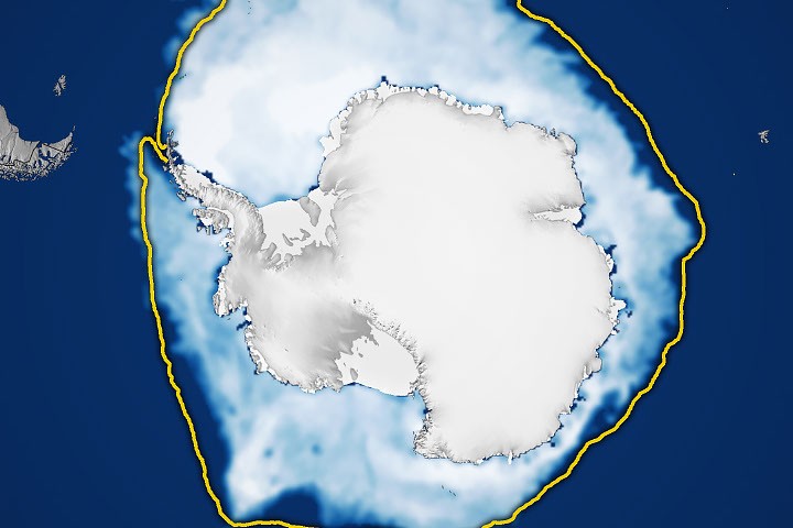
NASA and NSIDC say Antarctic sea ice likely peaked on September 14 at 17.59 million square kilometers, the third-lowest maximum on record. Ice has mostly stayed below normal since 2016, and NASA says scientists will keep watching to see if that is a long-term change or a statistical fluctuation.
The Scientist · Science desk
What happened
- The record low maximum and the record low minimum for Antarctic sea ice both came in 2023.
- Antarctic sea ice usually peaks in September, around the end of Southern Hemisphere winter, and retreats to a minimum in February.
- Sea ice extent counts only areas where ice concentration is at least 15 percent, a threshold scientists commonly use to call an area ice-covered.
- The measurement comes from passive microwave sensors on satellites, which see sea ice through clouds because microwaves pass through them.
Why it matters
- constraint Extent is an area count above a cutoff, so the ranking says how widely the ice spread. Thickness and volume are separate quantities and need their own measurements.
- contradiction NSIDC described the preceding summer minimum as near average, so one 'weak ice' label for 2026 flattens a year that looked ordinary at its low point and low at its high point. The two labels use different yardsticks, an average and a rank.
- decision Whoever summarizes the season picks a baseline, and the pick changes the story. Anchored on the record highs of the early 2010s, 2026 looks like a long fall; anchored on the full record, it is one more low year.
Third lowest is a rank, and a rank depends on its denominator. This one comes from a satellite record that began in late 1978 with NASA's Nimbus-7 [8]. Defense Meteorological Satellite Program instruments followed from 1987, NASA's Aqua covered 2002 to 2011, and Japan's GCOM-W entered the data in 2025 [8].
That record has swung hard. Winter extent set three straight highs in 2012, 2013 and 2014, and those came while Arctic ice was in steep decline [7]. The record low arrived nine years after the last of them [14]. Across 1979 to 2014 the total rose about 1 percent per decade, and NASA says it is uncertain whether that rise meant anything, because ice extents vary considerably from year to year [6]. We would not use one pole's trend to predict the other's.
Geography sets the annual cycle. Antarctica is a continent surrounded by ocean, so winter ice has room to expand, but that ice reaches into warmer latitudes and melts more in summer [12]. The thing this doesn't tell you is why the ice has been low. NASA's article describes what the satellites saw and leaves cause open.
We think the 2026 ranking fits the low-ice pattern NASA describes and adds one more weak winter to it. In NASA's wording, both the date and the extent are estimates [1][2].
What to watch
- Whether NSIDC's later analysis keeps September 14 and 17.59 million square kilometers as the peak, given that NASA calls both estimates.
- The February 2027 minimum, the usual low point, and whether it is near average again, as NSIDC called the March 2026 minimum, or low.
- Next September's maximum: a rebound would fit the small rebounds NASA notes, and another low would extend the run.
Clarity's read
What the record supports and how the coverage leans. The claims behind it follow.
Reality
- Evidence72
- Adoption
- Insufficient
- Hype gap−5
- Incentives
- Insufficient
- Confidence68
Claim ledger
Ranked by verification strength, evidence, and original report placement.
- [1]
According to NASA and the National Snow and Ice Data Center, Antarctic sea ice in 2026 likely reached its annual maximum extent on September 14.
- [2]
On that date the ice covered an estimated 17.59 million square kilometers (6.79 million square miles), the third-lowest maximum on record.
- [3]
Antarctic sea ice usually peaks in September, around the end of the Southern Hemisphere's winter, and retreats to a minimum in February.
- [4]
Both the record low minimum and the record low maximum for Antarctic sea ice occurred in 2023.
- [5]
Significant decreases in sea ice around Antarctica started in 2016; there have been years with small rebounds, but overall Antarctic sea ice coverage has largely remained lower than normal.
- [6]
From 1979 until 2014, total Antarctic sea ice increased by about 1 percent per decade; whether the increase was a sign of meaningful change is uncertain because ice extents vary considerably from year to year.
- [7]
For three consecutive years, from 2012 to 2014, satellites observed new record highs for winter sea ice extent, while Arctic ice was in steep decline.
- [8]
The satellite record began in late 1978 with data from NASA's Nimbus-7, followed by Defense Meteorological Satellite Program satellites starting in 1987 and NASA's Aqua between 2002 and 2011; in 2025 scientists began using observations from JAXA's GCOM-W satellite.
- [9]
NASA says scientists will continue to observe the area each year to find out whether the decline is part of a long-term change or a statistical fluctuation.
- [10]
The sea ice maps include only areas where ice concentration was at least 15 percent, a threshold scientists commonly use to count an area as ice-covered; the total area of these regions is called sea ice extent.
- [11]
Scientists determine sea ice extent with satellites carrying passive microwave sensors; sea ice emits more microwave energy than open water, and microwaves pass through clouds, so the satellites can observe sea ice regardless of weather.
- [12]
The Antarctic is a large continent surrounded by an ocean, so sea ice has more room to expand during winter; that ice also stretches into warmer latitudes, leading to more melting in summer.
- [13]
The reference list in NASA's article includes a National Snow and Ice Data Center post dated March 9, 2026, titled 'Antarctic sea ice extent arrives at a near-average minimum.'
- [14]
The record low maximum (2023) came nine years after the last of the three consecutive record highs (2014).
Sources
1 independent publisher whose own reporting we read for this story.
- nasa.govAntarctic Sea Ice Grows to Its 2026 Maximum
1 article · October 11, 2026
Topics and entities
Follow any of these and your For You feed starts watching them — no settings page required.
Topics
- Satellite Remote Sensing MissionsFollow
- Polar Climate Monitoring ProgramsFollow
- Antarctic sea iceFollow