Petermann's 30-square-mile calving was the small one: two bigger sections are already cracked
A Sentinel-1 radar pass caught the Aug. 4 break at Greenland's Petermann Glacier a day early. The two rifts still holding cover about 2.3 times the area that just left.
The Scientist · Science desk
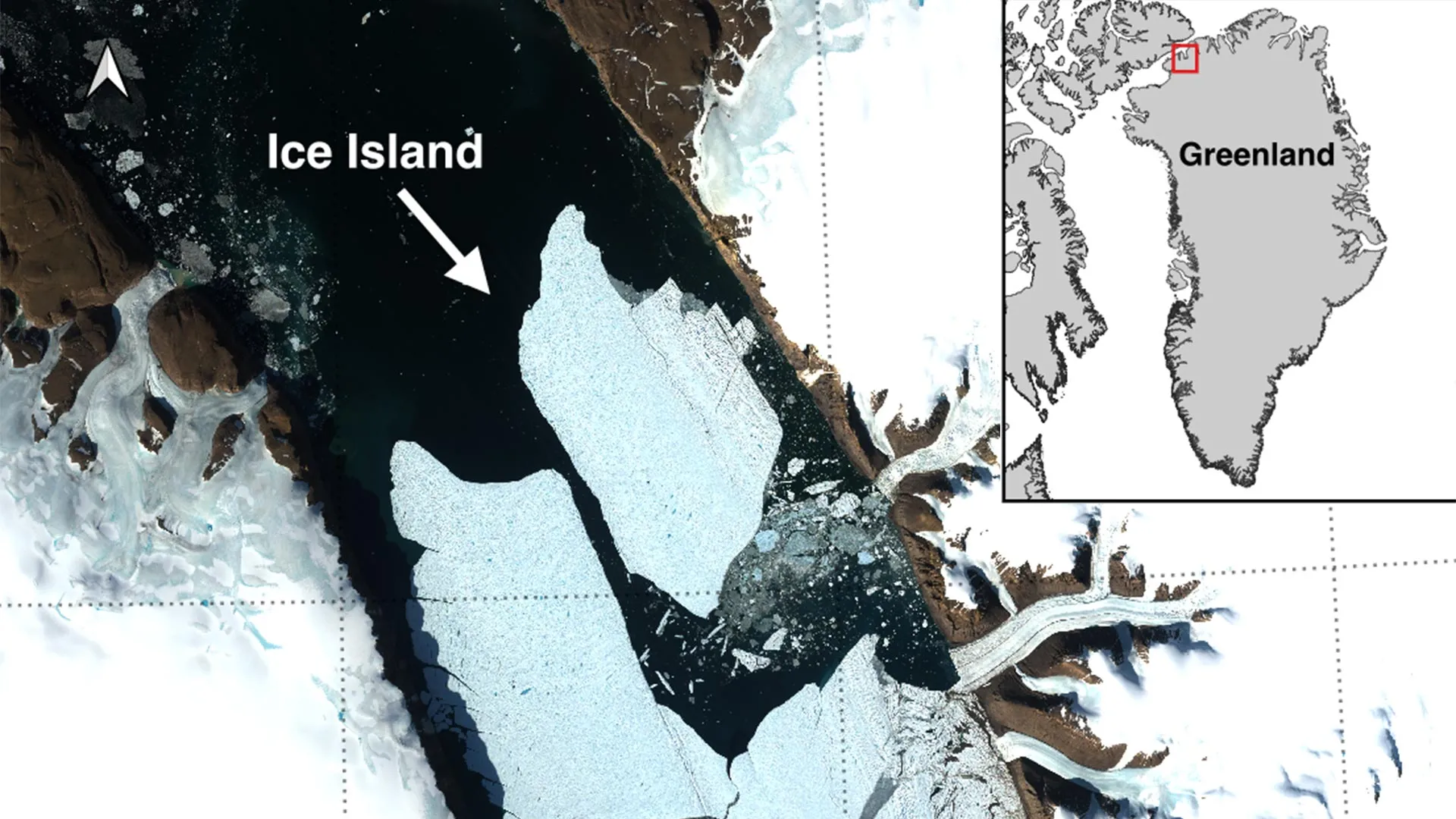
What happened
- Petermann Glacier in northwest Greenland shed a 76.4 square kilometre ice island on Aug. 4, 2026, its largest floating-ice loss since 2012.
- Sentinel-1 radar showed the centreline crack on Aug. 3 and confirmed full separation from the eastern side by 20:00 UTC the next day.
- The break was identified by a uOttawa doctoral student working with Stirling, Lancaster, Leeds and Environment and Climate Change Canada.
- Two further sections, projected at about 94 and 84 square kilometres, are expected to detach as existing rifts keep cutting.
Why it matters
- capability Stacked radar passes flagged spreading fractures roughly four months ahead of the break, which moves an event like this from something recorded after the fact to something with a usable warning...
- exposure The hazard to shipping and offshore operators grows as the slab breaks up, because the fragments that survive for years are the ones too small to hold on a radar track.
- precedent With most of the projected 254 square kilometres still attached, the next two losses are mapped rather than surprising, and Arctic ice-island forecasting now has a named test case to be scored...
- constraint Outside checking is limited by what was published: the tongue's total area has to be back-computed from a rounded 22 percent, so the baseline everyone cites carries an error bar nobody stated.
The number neither release prints is the size of the thing being subtracted from. Both give the output instead: three calvings totalling roughly 254 square kilometres, trimming the floating tongue by about 22 percent [11]. Read that percentage against the tongue as it stood before Aug. 4 and the tongue was around 1,155 square kilometres, with about 1,078 left now [26]. The event that got reported was therefore about 6.6 percent of it [27], and the lesser part of what the University of Ottawa team says is queued: the two sections still attached, at 94 and 84 square kilometres [9], come to 178 square kilometres, roughly 2.3 times the area that left on Aug. 4 [22]. The three figures sum to 254.4, so the published total and the published percentage are internally consistent [24].
Thickness differs between the two write-ups only in units. The uOttawa release puts the island at as much as 150 metres [5]; Discover says up to 500 feet [6], which is the same measurement rounded [23]. Treat 150 metres as an upper bound across the whole slab and the island carries on the order of 11 cubic kilometres of ice [28], a ceiling rather than a measurement, since the sources give no thickness field.
The detection chain is the part worth keeping. Sentinel-1 showed deterioration along the tongue's centreline on Aug. 3, and by 20:00 UTC on Aug. 4 the island had separated from the eastern side [4]. That was not the first warning: in April 2026, researchers stacked radar passes using interferometry and saw deformation and spreading fractures, according to NASA [18], about four months of lead on the break itself [29]. "We've anticipated this break for years, and seeing it finally happen is remarkable," said Adam Garbo, the uOttawa doctoral student who identified the event [8][7].
The comparison figures deserve a caveat the releases do not attach. The team's systematic Sentinel-1 record of the tongue starts in 2019 [7], so "largest since 2012" reaches seven years behind the start of their own monitoring [25]. Petermann's earlier large breaks came in 2008, 2010 and 2012 [19], meaning the quiet interval before this one ran 14 years [30]. Discover's framing is that the August event could have passed almost unnoticed without Copernicus Sentinel-1 [3], whose radar images through cloud and darkness [17]. The public description arrived 22 days after separation, in a release dated Aug. 26 [31][21].
Then there is the object itself, drifting out of a tongue that extends into Nares Strait [20]. "These are thick blocks of ice that can drift for years," said Abigail Dalton of the Canadian Ice Service, adding that they fracture into smaller, harder-to-track pieces that threaten vessels and resource operations [13]. Environment and Climate Change Canada is monitoring its movement and assessing risk to shipping and offshore infrastructure, as it has after previous Arctic ice shelf calvings [12]. Anna Crawford of the University of Stirling notes that tabular bergs this size are common around Antarctica and rare in the Arctic [14], which is the case for spending observation time on it: what it teaches about calving and deterioration transfers to glacier dynamics, sea-level rise and ocean conditions elsewhere [15].
What to watch
- Whether the April interferometry method delivers comparable lead time on the 94 and 84 square kilometre sections, or whether either goes without a flagged precursor.
- Environment and Climate Change Canada's drift and fragmentation record for the island, including when pieces fall below reliable detection.
- Publication of a measured tongue area and thickness field, which would replace the back-computed 1,155 square kilometre baseline and the 150 metre upper bound.
Clarity's read
What the record supports and how the coverage leans. The claims behind it follow.
Reality
- Evidence66
- Adoption61
- Hype gap+9
- Incentives57
- Confidence68
Claim ledger
Ranked by verification strength, evidence, and original report placement.
- [1]
On August 4, 2026, Petermann Glacier in northwest Greenland released a 76.4 square kilometre ice island, its largest loss of floating ice since 2012 and the biggest Arctic calving event since 2020.
- [2]
The chunk that broke away on Aug. 4, 2026 was approximately 30 square miles, comparable in size to Manhattan.
- [3]
Discover reports the event might have gone almost unnoticed if not for Europe's Copernicus Sentinel-1 mission, a space-based radar observatory.
- [4]
Sentinel-1 images showed clear signs of deterioration along the centerline of the ice tongue on August 3, and by 20:00 UTC on August 4 the new ice island had fully separated from the glacier's eastern side.
- [5]
The newly separated tabular iceberg may be as much as 150 metres thick.
- [6]
Discover describes the new ice island as up to 500 feet thick.
- [7]
Scientists have tracked Petermann's floating ice tongue with satellite observations since 2019; the August event was identified by Adam Garbo, a PhD student in glaciology at the University of Ottawa, in a collaboration involving uOttawa, the University of Stirling, Environment and Climate Change Canada, Lancaster University and the University of Leeds.
- [8]
Garbo: "Petermann Glacier has long been one of Greenland's largest remaining ice tongues... We've anticipated this break for years, and seeing it finally happen is remarkable."
- [9]
Two additional large sections of the floating ice tongue are expected to detach as long-developing rifts continue to cut through the ice, projected to measure about 94 square kilometres and 84 square kilometres.
- [10]
Discover reports the two further sections measure roughly 37 and 33 square miles and could break away as existing cracks grow.
- [11]
If both further sections break away, the three calving events combined would remove approximately 254 square kilometres from Petermann's ice tongue, reducing it by about 22 percent.
- [12]
Environment and Climate Change Canada is monitoring the ice island's movement, as it has after previous Arctic ice shelf calving events, while evaluating potential risks to vessels and offshore infrastructure.
- [13]
Abigail Dalton of the Canadian Ice Service, Environment and Climate Change Canada: "These are thick blocks of ice that can drift for years. Over time, they fracture into smaller, harder-to-track pieces that pose hazards to vessels and resource operations."
- [14]
Anna Crawford of the University of Stirling: large tabular icebergs are relatively common in the Southern Ocean around Antarctica, but Arctic ice islands are far rarer, and studying them yields knowledge transferable across polar regions.
- [15]
Crawford said such study is critical for understanding how the calving and deterioration of ice islands affect glacier dynamics, sea-level rise and the ocean environment.
- [16]
Garbo and collaborators plan to follow the aftermath with satellite imagery, aerial observations and tracking data.
- [17]
Sentinel-1's radar imaging system operates day and night and is unbothered by cloud cover, according to ESA's SentiWiki.
- [18]
In April 2026, researchers compared multiple radar observations using interferometry, and the images revealed deformation and spreading fractures in the ice tongue, according to NASA.
- [19]
Petermann has experienced large calving events before, including major breaks in 2008, 2010 and 2012.
- [20]
Petermann Glacier's floating ice tongue extends into the Nares Strait and is one of the longest remaining floating glaciers in Greenland.
- [21]
The University of Ottawa release describing the calving is dated August 26, 2026.
- [22]
The two sections still attached total 178 square kilometres, about 2.3 times the area lost on Aug. 4.
- [23]
150 metres equals about 492 feet, so the "up to 500 feet" and "as much as 150 metres" thickness figures are the same measurement in different units.
- [24]
The three individual areas sum to 254.4 square kilometres, matching the published combined total of about 254 square kilometres.
- [25]
The team's satellite monitoring record begins in 2019, seven years after the 2012 event used as the comparison point for this calving's size.
- [26]
Taking 254 square kilometres as about 22 percent of the ice tongue as it stood before Aug. 4 implies a pre-calving tongue area of roughly 1,155 square kilometres, and roughly 1,078 square kilometres remaining after the Aug. 4 loss.
- [27]
The Aug. 4 ice island amounts to about 6.6 percent of the implied pre-calving tongue area.
- [28]
At the stated maximum thickness of 150 metres applied across its whole area, the new ice island represents about 11 cubic kilometres of ice as an upper bound.
- [29]
The April 2026 interferometry warning preceded the Aug. 4, 2026 calving by about four months.
- [30]
The interval between Petermann's 2012 break and the 2026 event is 14 years.
- [31]
The release describing the calving appeared 22 days after the ice island separated.
Sources
2 independent publishers whose own reporting we read for this story.
- discovermagazine.comManhattan-Sized Iceberg Breaks Off Greenland Glacier, and Two More Could Follow
1 article · August 26, 2026
- sciencedaily.comManhattan-sized ice island breaks off Greenland’s Petermann Glacier
1 article · August 26, 2026
Topics and entities
Follow any of these and your For You feed starts watching them — no settings page required.
Topics
Entities
- University of StirlingFollow
- Copernicus Sentinel-1Follow
- Nares StraitFollow
- Petermann GlacierFollow
- Adam GarboFollow
- European Space AgencyFollow
- Anna CrawfordFollow
- University of OttawaFollow
- NASAFollow
- Lancaster UniversityFollow
- Environment and Climate Change CanadaFollow
- Abigail DaltonFollow
- University of LeedsFollow