Remnants of Hurricane Isaias put north-west Scotland under a 70mph wind warning
Met Office issues a yellow wind warning for the Highlands and Western Isles, with gusts up to 70mph possible, as Isaias remnants feed a new Atlantic low. BBC Weather's forecast keeps the low's centre hundreds of miles offshore, with most of England and Wales dry and warmer than average.
The Scientist · Science desk
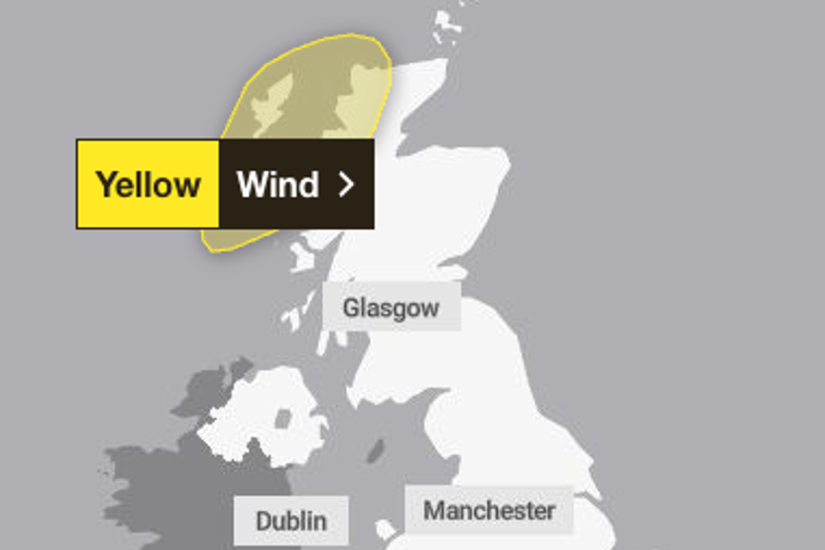
Key figures: gusts over the sea between Iceland and the Faroe Islands could exceed 110mph. Widespread gusts of at least 50mph are likely, up to 60mph. Gusts of 40mph are possible in other parts of Scotland, Northern Ireland, northern England and north-west Wales.
| Figure | Value | Note | Claim |
|---|---|---|---|
| Sea gusts between Iceland and the Faroes, could exceed | 110 mph | 6 | |
| Widespread gusts likely, at least | 50 mph | up to 60mph | 8 |
| Possible gusts in other parts of Scotland | 40 mph | Also N Ireland, N England, NW Wales | 9 |
What happened
- Isaias was the first Atlantic hurricane of its season, made landfall in the southern United States last Friday, and weakened rapidly into remnants.
- Those remnants moved out over the Atlantic, were picked up by a powerful jet stream, and developed a new low that has been through explosive cyclogenesis.
- The yellow warning for the Highlands and Western Isles is valid on Wednesday from 10:00 until 19:00 BST.
- A weather front then moves slowly south, with cooler air behind it and temperatures close to the seasonal norm through Friday and the weekend.
Why it matters
- exposure Rail, air and ferry operators in the north-west, drivers of high-sided vehicles on roads and bridges, and local power supply sit inside the warned risk for nine hours on Wednesday.
- constraint Planning from the warning polygon alone misses Shetland, where 50mph gusts are anticipated, and the 40mph gusts possible across other parts of Scotland, Northern Ireland, northern England and north-west Wales.
- constraint The outlook offers no second Atlantic low after this one, since computer models suggest high pressure will settle near the UK and keep such systems at bay for the time being.
Explosive cyclogenesis, also called a "weather bomb", is the label BBC Weather gives to how this low developed [5]. Its UK footprint depends on where the jet stream puts the centre. The jet stream is steering it close to Iceland, and gusts over the sea between Iceland and the Faroe Islands could exceed 110mph, according to the BBC forecast. Nothing this severe is expected near the UK [6]. Set against the 70mph ceiling in the Highlands warning [2], that is a gap of more than 40mph [18].
Inside the warning area, 70mph is the top of the range. BBC Weather expects widespread gusts of 50-60mph, with 70mph possible on exposed coasts and hills around midday [8]. The 70mph figure is tied to the middle of a nine-hour window [17].
The BBC article does not include the low's central pressure or any measure of forecast spread. The 70mph figure is one number from one published forecast. As long as the track stays where the BBC places it, we think the warning's own wording is the right size for it: a high risk of moderate impacts [16].
The same low drives the warmth. It is set to send warm south-westerly winds across the country [15]. BBC Weather puts temperatures in the mid to high teens Celsius, possibly 20C in a few places in southern England, which leaves most places 2-4C above the mid-October average [11]. The forecast peak rises to 22C in East Anglia on Thursday [12].
What to watch
- Whether the Met Office changes the Wednesday warning's area or gust figure as the low's track firms up.
- Whether the front's slow move south on Thursday and Friday brings the forecast overnight frost to eastern coasts.
- Whether high pressure settles near the UK as the computer models suggest, ending the run of Atlantic lows.
Clarity's read
What the record supports and how the coverage leans. The claims behind it follow.
Reality
- Evidence70
- Adoption
- Insufficient
- Hype gap−10
- Incentives
- Insufficient
- Confidence65
Claim ledger
Ranked by verification strength, evidence, and original report placement.
- [1]
A weather system containing the remnants of Hurricane Isaias is forecast to send gales, heavy rain and a surge of warm air to parts of the UK this week.
- [2]
A Met Office yellow warning has been issued for parts of the Highlands and Western Isles with the risk of gusts touching 70mph (113km/h) in places.
- [3]
The centre of the low, and its most significant impacts, will stay hundreds of miles from UK shores.
- [4]
Hurricane Isaias was the first Atlantic hurricane of the season and made landfall in the southern United States last Friday; it weakened rapidly and ceased to be a hurricane.
- [5]
The Isaias remnants emerged over the Atlantic and were scooped up by a powerful jet stream, developing a new area of low pressure undergoing explosive cyclogenesis, also referred to as a weather bomb.
- [6]
The jet stream is steering the centre of the storm close to Iceland, where blizzards are a threat; wind gusts over the sea between Iceland and the Faroe Islands could exceed 110mph, but nothing this severe is expected in the vicinity of the UK.
- [7]
The Met Office yellow weather warning is valid on Wednesday from 10:00 until 19:00 BST.
- [8]
Widespread gusts of 50-60mph are likely, with 70mph possible for exposed coasts and hills around the middle of the day.
- [9]
Outside the warning area, Shetland is anticipated to see 50mph gusts, with less risk of disruption, and 40mph gusts are possible in other parts of Scotland, Northern Ireland, northern England and north-west Wales.
- [10]
Heavy rain will affect parts of Scotland and Northern Ireland but much of England and Wales will remain largely dry with spells of sunshine.
- [11]
Temperatures will widely climb into the mid to high-teens Celsius, possibly peaking at 20C in a few locations in southern England, leaving most places 2-4C above the mid-October average.
- [12]
The warmth will linger in many parts of England and Wales on Thursday, with temperatures expected to peak at 22C in East Anglia.
- [13]
A weather front will move slowly southwards, with cooler conditions behind it spreading south through Friday and over the weekend, bringing temperatures much closer to the seasonal norm.
- [14]
Computer models suggest high pressure will then settle close to the UK, which should keep Atlantic low pressure systems at bay for the time being, bringing long spells of dry weather for many.
- [15]
The deep area of low pressure is set to send warm south-westerly winds across the UK.
- [16]
The warning flags a high risk of moderate impacts including disruption to rail, air and ferry transport, delays on roads and bridges (especially for high-sided vehicles) and possible short-term power cuts.
- [17]
The Met Office warning window is nine hours long.
- [18]
The highest gusts forecast over the sea near Iceland and the Faroes (above 110mph) exceed the UK warning ceiling (70mph) by more than 40mph.
Sources
1 independent publisher whose own reporting we read for this story.
- bbc.co.ukGales and heavy rain to impact UK as yellow wind warning issued
1 article · October 13, 2026
Topics and entities
Follow any of these and your For You feed starts watching them — no settings page required.
Entities
- BBC WeatherFollow
- Hurricane IsaiasFollow
- UK Met OfficeFollow