Science2 publishersIndependently confirmed3 min readPublished
Exposure mapping counts 294,000 Nepalis living in Himalayan flood-prone valleys
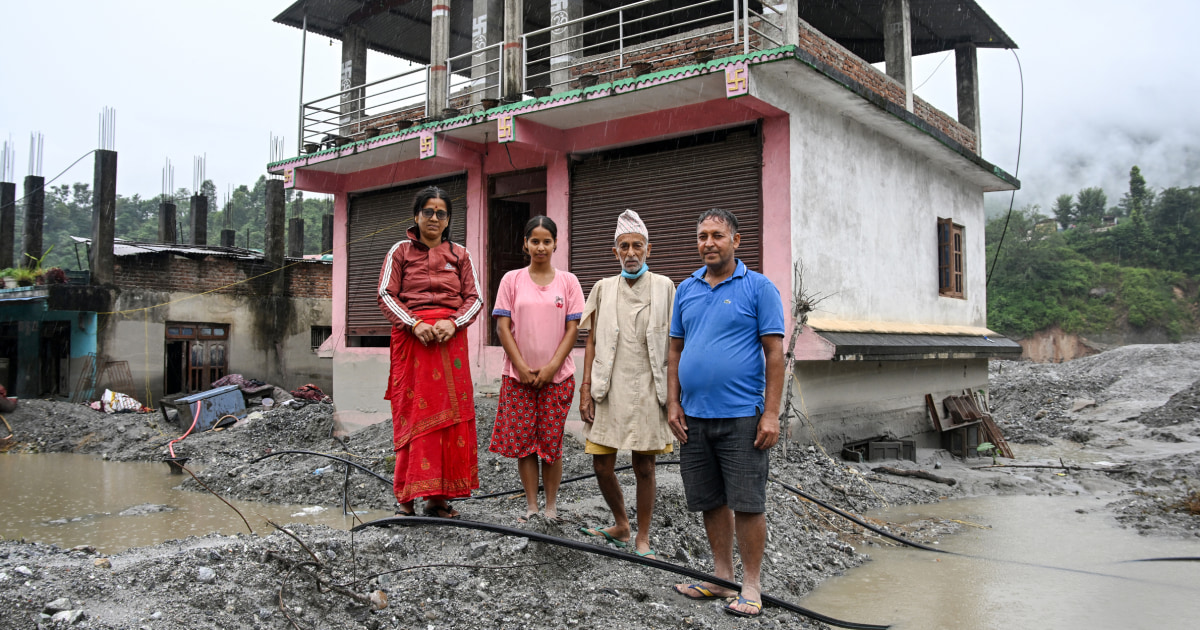
Researchers mapping Nepal's mountain rivers count about 294,000 people living in flood-prone valleys below the Himalayas, and say the number is still rising. Roughly 108,000 of them are downstream of glacial lakes that can breach and flush water down the valleys all at once.
The Scientist · Science desk
What happened
- Satellite imagery showed the built-up area exposed to potential flooding in Nepal's mountain catchments grew 46 percent between 2016 and 2023.
- The researchers mapped every river draining Nepal's basins along the Tibet and India borders and flagged land within 50 kilometers downstream of a glacial lake or headwater as potentially exposed.
- The August avalanche off the nearly 24,000-foot Langtang Lirung peak drove a debris flow about 120 miles downstream, killing at least 1,455 people, with 5,285 still missing and nearly 14,000 rescued.
- The findings were published Thursday in Scientific Reports after months of peer review, work the team began in the fall of 2025.
Compiled by The ScientistSomething wrong?How this is made
Why it matters
- decision Where Nepal puts the next road, lodge or school along these valleys now sets who is exposed, because the study ties the coming decades of disaster risk to development decisions made today.
- capability The screening map tells Nepal which valleys to point its scarce high-resolution flood modeling at first, a triage the country could not do before.
- constraint Exposure is only one part of risk, so even a correctly counted population still depends on building type, early warning and evacuation to decide whether a flood becomes a death toll.
- contradiction By Chapagain's account August's flood rose well beyond the depth the model assumed, so the true number of people exposed may be larger than the map shows.
Most work on Himalayan hazards asks what is making the mountains more dangerous, such as melting glaciers and thawing permafrost. The authors asked instead who has built in the path of a flood, and note that far less attention has been paid to that exposure than to the causes of the hazard [26]. Set aside the people living directly below glacial lakes and roughly 186,000 remain, exposed instead to rivers running high off the mountain headwaters [27].
The figure is a screening estimate. The team measured how high each building sits above the nearest river channel, a metric called height above nearest drainage, and matched it to satellite images of where buildings stand [7]. In a steep valley two houses can be close together on the ground and tens of meters apart in height, and that vertical gap decides whether rising water reaches them [8].
The metric cannot show whether a given building will flood. Detailed flood hazard mapping, which models how water actually moves down a channel, does not exist for much of Nepal. Earlier national estimates simply drew a one-kilometer buffer around alpine rivers and counted what fell inside [10]. "We're collecting very high-resolution elevation models to run some of the detailed flood hazard maps so we can focus on the most exposed hot spots," said Scott Watson, a senior research fellow at the University of Leeds who studies glacial lakes [18][23].
One depth in the model may already be too low. Dipesh Chapagain, a senior scientist at the United Nations University Institute for Environment and Human Security, said the Aug. 26 flood on the Bhote Koshi raised water levels by roughly 330 feet in some communities. That is far above the 164-foot rise the paper modeled [24][12][19][6]. "The risk could even be higher" than the paper suggests, Chapagain said. "This event set a new level, a new threshold" [20].
The valley floors are among the only flat, accessible ground in the mountains, and the rivers are the natural routes through them [14]. Watson said the building is "driven by tourism and the trade routes," and that the recent disaster hit the main trade route between Nepal and the Tibetan Plateau [15]. Once a road reaches a valley, the authors note, homes, schools and health facilities tend to follow [16].
The authors do not say floods are inevitable everywhere, or that all building near rivers should stop [21]. Nepal called off its search for the missing after more than a month, and Chapagain said the immediate task is temporary shelter for thousands, with no plan yet for permanent resettlement beyond a rule that new construction go in safe areas [25].
What to watch
- The high-resolution flood hazard maps Watson's team is assembling for the exposure hotspots, which would replace the screening estimate with modeled flood depths.
- Whether Nepal writes land-use zoning into reconstruction along the trade-route valleys, or rebuilds in the same flood paths.
- Nepal's still-undecided plan for permanently resettling the Bhote Koshi flood survivors.
Clarity's read
What the record supports and how the coverage leans. The claims behind it follow.
Reality
- Evidence60
- Adoption
- Insufficient
- Hype gap−10
- Incentives30
- Confidence62
Claim ledger
Ranked by verification strength, evidence, and original report placement.
- [1]
About 294,000 people, and growing, live downstream and exposed to potentially catastrophic flood risk in areas that drain from Nepal's high mountain basins.
ReportedSupportedSource: Researchers published in Scientific Reports2 sources— create a free account to open themView cited source - [2]
The study estimates almost 300,000 people live in flood-prone areas across the Nepalese Himalayas.
- [3]
About 108,000 of the exposed people are downstream of glacial lakes.
- [4]
More than 100,000 of the exposed people are downstream of glacial lakes.
- [5]
Between 2016 and 2023, the built-up areas potentially exposed to flooding in the region increased by 46%.
- [6]
The researchers mapped all rivers originating in the transboundary areas of Nepal along the border with Tibet and India, isolated areas within 50 kilometers (31 miles) downstream of glacial lakes or river headwaters, then mapped what would be exposed in a flood that raises water 50 meters (164 vertical feet) downstream.
- [7]
The team measured flood exposure using a metric called height above nearest drainage, which estimates how high a building sits above the nearest river channel, combined with satellite-derived building data.
- [8]
In steep mountain valleys two locations may be only a short distance apart horizontally but separated by tens of meters vertically, giving very different flood exposure.
- [9]
The researchers began the analysis in fall 2025 and published it for the first time in the journal Scientific Reports on Thursday after months of academic peer review; they say it is best viewed as a rough draft and that more thorough analysis is still needed.
- [10]
Detailed flood hazard mapping is not available for much of Nepal, unlike in the US, and previous efforts to gauge exposure simply drew 1-kilometer (0.62-mile) buffers around alpine rivers.
- [11]
The August disaster, a rock and ice avalanche off the almost 24,000-foot peak Langtang Lirung, caused a debris flow that traveled about 120 miles; it killed at least 1,455 people, at least 5,285 remain missing, and nearly 14,000 were rescued, per Nepali authorities.
- [12]
On Aug. 26 a rock and ice avalanche triggered a huge flood that swept through a steep valley in Nepal, leaving thousands dead and missing.
- [13]
The authors say development decisions being made today will shape disaster risk for the coming decades.
- [14]
In the Himalayas, valley floors are some of the only flat and accessible places to build, and rivers provide natural routes through the mountains; the recent disaster struck Nepal's primary trade route to China along the Bhotekoshi-Trishuli rivers.
- [15]
Watson said the development is "driven by tourism and the trade routes" and that "the recent disaster was on the main trade route between Nepal and the Tibetan Plateau."
ReportedSupportedSource: Scott Watson, University of Leeds2 sources— create a free account to open themView cited source - [16]
Once a road connects a valley, other development often follows, including homes, schools and health care facilities.
- [17]
Many of the glacial lakes are pools of water dammed by ice that could fail and release a flush of water all at once.
- [18]
"We're collecting very high-resolution elevation models to run some of the detailed flood hazard maps so we can focus on the most exposed hot spots," Watson said.
- [19]
Chapagain said the August flooding on the Bhote Koshi river raised water levels by roughly 330 feet in some communities.
- [20]
"The risk could even be higher" than the paper suggests, Chapagain said. "This event set a new level, a new threshold."
- [21]
The study does not suggest that floods are inevitable everywhere or that all development near rivers should stop.
- [22]
Exposure to floodwaters is only one component of risk; building type, early warning systems, preparedness and evacuation planning also influence whether a hazardous event becomes a disaster.
- [23]
Scott Watson is a senior research fellow at the University of Leeds in England who studies glacial lakes.
- [24]
Dipesh Chapagain is a senior scientist at the United Nations University Institute for Environment and Human Security, a Nepali scientist who studies climate change and flooding.
- [25]
Nepal called off its search for the missing in the Bhote Koshi flooding after more than a month; Chapagain said the focus now is to build temporary settlements for thousands of flood victims, that there is no concrete plan yet for permanent resettlement, and that new construction must be prioritized in safe areas.
- [26]
Scientists have largely focused on what causes these hazards, and far less attention has been paid to exposure, meaning the people, buildings and infrastructure potentially at risk.
- [27]
About 186,000 of the exposed people live downstream of river headwaters rather than directly below a glacial lake.
Sources
2 independent publishers whose own reporting we read for this story.
- nbcnews.comHundreds of thousands still at risk of climate-linked floods in Nepal
1 article · October 8, 2026
- phys.orgAlmost 300,000 people now live in flood‑prone areas in the Nepalese Himalayas—new research
1 article · October 8, 2026
Topics and entities
Follow any of these and your For You feed starts watching them — no settings page required.
Entities
- Bhote KoshiFollow
- NepalFollow
- The ConversationFollow
- Scott WatsonFollow
- Langtang LirungFollow
- Scientific ReportsFollow
- Dipesh ChapagainFollow
- United Nations University Institute for Environment and Human SecurityFollow
- Height above nearest drainageFollow
- University of LeedsFollow