Science1 publisher2 min readPublished
NASA and IBM fold four lunar instrument archives into one reusable AI backbone
The Lunar Foundation Model is trained by hiding parts of co-registered map tiles and making the network fill them back in, and its most interesting design choice is that it is told where the sun was rather than left to work it out from the shadows.
The Scientist · Science desk
What happened
- NASA and IBM described their Lunar Foundation Model in a technical paper dated Sept. 10 and shared with Live Science.
- The archives it targets come from optical cameras, laser altimeters, radar reflectance tools and elemental spectrometers, and unifying them has been labor-intensive and computationally demanding.
- It trains on SomBench, a layered dataset of nearly 2 million overlapping tiles the team assembled so readings from different instruments, resolutions and viewing angles line up on the same patch of ground.
- The team built it as a single reusable backbone and released it freely on Hugging Face so other researchers can fine-tune it for their own questions.
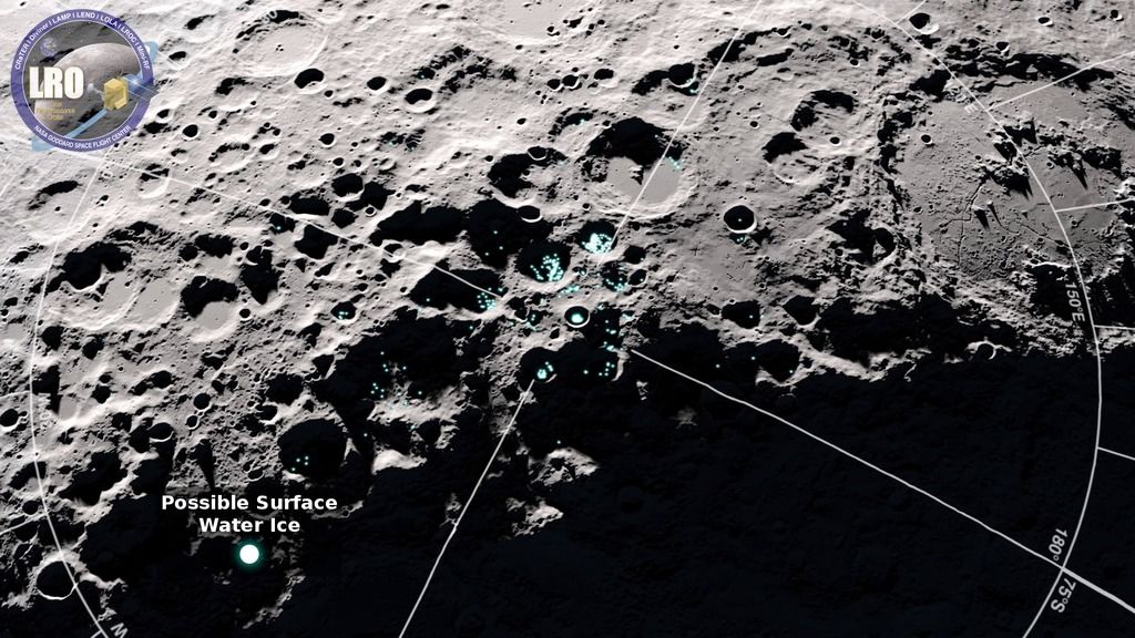
- One target is combing the data for heavily shadowed sites that often conceal subsurface ice, which matters for establishing long-term lunar bases.
Compiled by The ScientistSomething wrong?How this is made
Why it matters
- exposure NASA wants crater maps from this to plot safe landing zones, so a failure mode in the model stops being a research question and becomes a risk attached to a specific slope.
- constraint With the model and its yardstick both coming from the same team and no reported margin over the general-purpose backbone, anyone outside the partnership who adopts it is also doing the validating.
- cost The expensive cross-instrument alignment is paid once by IBM and NASA rather than by every project that wants a fused map, which changes what a small group with no pipeline budget can attempt.
- precedent A moon-specific backbone alongside the existing weather, geospatial and heliophysics models sets the expectation that each observing archive gets its own pretrained model rather than borrowing one from photo recognition.
Shadow on an airless body is both the nuisance and the signal. Relief is read from shading, and the same low sun that picks out a ridge can flood a crater floor with black that looks like missing data; a frame shot at another hour washes the same geology flat [10]. A general vision model has to learn to separate illumination from topography from pixels alone. The Lunar Foundation Model is handed the answer instead: solar angles and spacecraft positions enter the architecture as explicit metadata, so capacity that would go into undoing the lighting can go into the terrain [14]. That is a physics prior, and it is the part of the design most likely to earn its keep.
The second engineering problem is scale. NASA's Lunar Reconnaissance Orbiter and its companions deliver regional maps at 100 metres per pixel and terrain scans at 1 metre per pixel [9], a factor of 100 in linear resolution and 10,000 in ground area sitting behind each pixel [16]. The coarse layers carry ultraviolet reflectance and elevation; the fine ones carry detailed camera frames with meter-scale slope and orientation, and thermal behaviour, surface mineralogy and local gravity anomalies are layered in alongside [12].
Training hides parts of a tile and asks the model to predict what was concealed, over millions of examples, until it has learned how lighting, terrain structure and physical geography move together [13]. That objective rewards a model for knowing how elevation and visible brightness co-vary across the archive. What it does not tell you is whether the model finds a crater it has never seen, or ice in a floor that is never lit. Reconstruction loss and crater recall are different numbers, and the account of the paper given to Live Science reports neither a task-level score nor a margin over the SwinV2-B backbone it is meant to displace [17][3].
The relationships the model absorbs are statistical associations between co-registered instruments [13]. That is solid ground for filling in a channel you did not observe. It is thinner ground for the inferential work further down the list, such as collating volcanic features into a story about the moon's thermal evolution [8], where the quantity of interest was never in the training tiles at all.
If the lighting prior is doing the work the architecture implies, it should show up as sample efficiency: fewer hand-labelled craters needed to reach a map of given quality than a general-purpose backbone requires. That is a measurable claim about a scarce resource, labelled lunar imagery, and it is the one worth holding the model to.
What to watch
- A fine-tune published by a group outside NASA and IBM, which is the first real test of the reusable-backbone claim.
- A crater-detection or polar-ice score on held-out tiles rather than reconstruction loss, showing whether the lighting prior transfers to the task.
- Whether NASA landing-site selection work begins citing LFM-derived crater maps.