Product1 distinct publisher3 min readPublished
Q-CTRL's trial moves gravity-based navigation from lab result toward shipboard fitting, which means the hard questions now sit with map coverage and with how much error piles up on a long unaided run.
The Product Desk · Product desk
Compiled by The Product DeskSomething wrong?How this is made
Follow any of these and your For You feed starts watching them — no settings page required.
build
Starlink retires Global Roam on August 17, and ocean crews get the metered price list1 distinct publisher
science
A sensor tuned to its own noise beats the textbook entangled state by 0.698 dB1 distinct publisher
leadership
The trainee writes the syllabus: why a NATO camp refuses to teach Ukrainians drone piloting1 distinct publisher
product
The Royal Navy ran a radar network on a British atomic clock instead of GPS1 distinct publisher
Every position GravNav reports is a lookup. The sensor measures the local gravity field and compares it against a stored map of that field, which is the reason Q-CTRL moved to gravity after demonstrating its MagNav magnetic sensor in ground and airborne trials [3][6]. Interesting Engineering's account says gravity maps are more widely available and better suited to maritime vessels for technical reasons [7]. Availability, resolution and map currency are three separate properties, and the account speaks only to the first. A buyer who takes this seriously inherits a map supply chain: who surveyed the water you operate in, and how a corrected map gets onto the box once it is fitted.
The headline ratio needs the same handling. One nautical mile is 1,852 metres, so the stated bound is a circle a little under two kilometres across [13]. The same sentence describes that result as ten times the accuracy of conventional satellite navigation [2]. A ratio and an absolute bound are not the same quantity, and the report names no baseline system and no voyage length, so there is no way to see how the error behaved over the run [14].
The demand side reads more cleanly. Interesting Engineering puts recorded GPS jamming at more than 978,000 instances globally in 2026 [8], which averages roughly 2,680 a day [12]. That number argues for buying something, though it offers little guidance on what to buy, because a count of incidents says nothing about how long any single one of them leaves a hull without a fix, and duration is the whole specification here.
Q-CTRL chief executive Michael J. Biercuk framed the work as a race in which adversaries are not waiting [9]. Retired US Marine Corps Lieutenant General Steve Sklenka, quoted in the same release, called it a credible path to navigation without external satellite signals, of the kind distributed maritime operations and contested logistics need when GPS is denied [10]. Credible path is the load-bearing phrase, and it is doing honest work.
The grid that sorts this for a program office has two axes: how good the gravity map is in the water you actually sail, and how long you need to run unaided. With a good map and short runs, the system can carry position on its own. With a good map but multi-day runs, it functions as a drift check on the inertial stack until someone publishes error against elapsed hours. With a thin map and short runs, what has been bought is one corridor. With a thin map and long runs, the money is funding a hydrographic survey while calling it a navigation program.
The recommendation is to fund a fitting and an instrumented evaluation rather than a fleet decision, and the tradeoff is that the year of trials is how you obtain the error-versus-time curve the announcement did not supply [14].
Ranked by verification strength, evidence, and original report placement.
Quantum sensors work passively by measuring physical properties such as gravitational or magnetic fields and comparing them with a previously prepared map; because the sensor neither sends nor receives an external signal, it cannot be spoofed by a fake incoming signal.
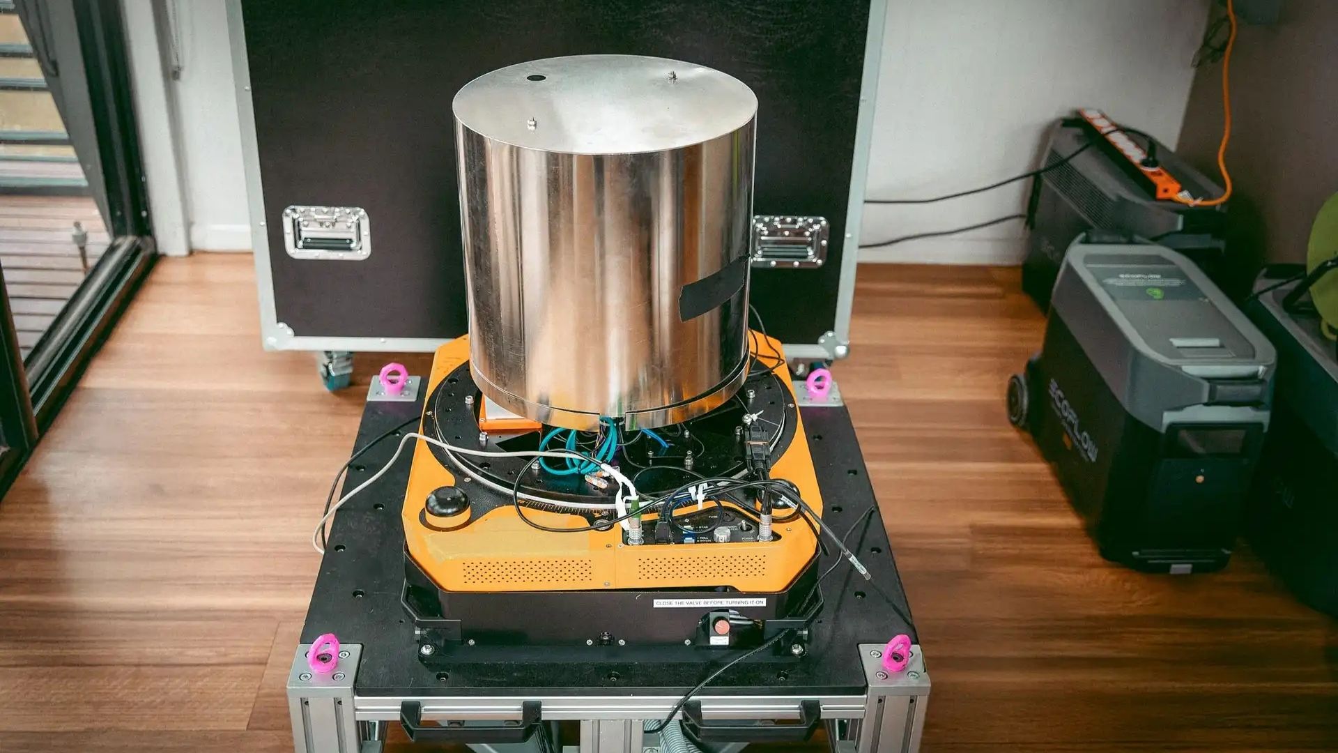
Q-CTRL, an Australian quantum software company based in Sydney, demonstrated GPS-free navigation at sea during trials in the Coral Sea, its first field demonstration of the system for maritime environments.
For the demonstration the system was installed in the passenger cabin of the ship and worked autonomously.
Q-CTRL previously built MagNav, which used a quantum sensor to detect changes in magnetic fields, and after ground and airborne trials turned to GravNav, which senses changes in gravity fields.
Michael J. Biercuk, chief executive and founder of Q-CTRL, said in a press release that the proliferation of GPS-jamming and spoofing instruments highlights that adversaries are not waiting and there is no time to lose in leading the race to derive defence advantage from quantum technology.
Steve Sklenka, Lieutenant General, US Marine Corps (Ret), said in the press release that Q-CTRL's demonstration shows a credible path to accurate navigation without reliance on external satellite signals, and that this is exactly what distributed maritime operations and contested logistics require to function when GPS is denied.
Distinct publishers with included, body-backed reporting in this cluster.
1 article · August 28, 2026
Evidence-backed comparisons of source perspectives and observed adoption signals. Read the methodology
Which Builder, Operator, and Investor concerns the observed source mix emphasized—not a truth score.
Evidence, demonstrated adoption, hype gap, incentives, and confidence are assessed independently, each on its own current evidence. How these are measured.
One outlet, one press release, no measurement narrative
Trace every load in this story back and you arrive at the same Q-CTRL release: the tenfold figure, the nautical-mile bound, the software credit, the world-first framing, both quotations. Interesting Engineering relays it competently but adds no independent observation. What would make the result assessable — the comparison receiver, the hours run unaided, the drift rate, the gravity map behind the fix — is absent, so the strongest verifiable facts are that the trial happened and what was said about it.
One shipboard run; nothing fielded
The trajectory is real — ground and airborne trials for the magnetic sensor, now a sea run for the gravity one — but it stops at a demonstration. No navy, shipping line or programme office is named as taking delivery, no follow-on exercise is scheduled in this reporting, and the only vessel involved is unidentified. A retired general's approval is a credible signal about the requirement, not evidence that anyone has bought the answer.
World-first framing outruns the disclosed numbers
The gap here is not in the engineering, which may well be as good as claimed — it is in the accounting. A priority claim ('world's first', nothing like it in decades) and a performance multiple are both published without the one thing that would ground them: what the sensor was measured against, and for how long. Add a jamming total quoted for a year still in progress, and the rhetoric is running a few lengths ahead of the disclosure.
A defence pitch, quoted as reported
The founder's line is not a technical statement, it is a call for urgency in a procurement race, and the corroborating voice is a retired US Marine lieutenant general speaking in the company's own release — his relationship to Q-CTRL is not disclosed. Interesting Engineering's incentive runs the other way but in the same direction: a world-first quantum headline is worth traffic. Nobody in this story is positioned to press on the missing drift number.
Sure what was claimed, blind to what was measured
We can be quite confident about the record: who ran the trial, where, how the unit was installed, what figures were announced and who said what. The uncertainty is entirely about substance, and it is uncertainty no additional reading of this reporting can reduce — with one publisher relaying one release, there is nothing here to cross-check the tenfold claim against.