Science1 publisher3 min readPublished
273 seismic stations resolve the Los Angeles basin in three dimensions
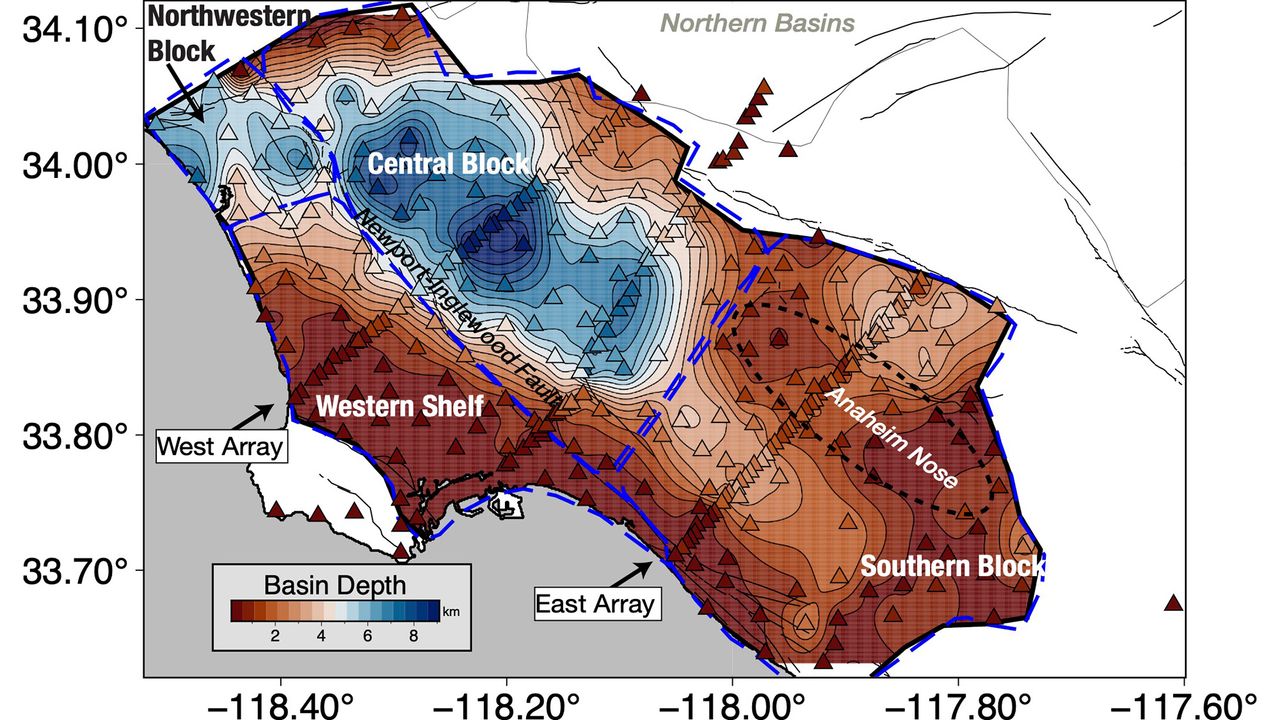
A new model puts up to 6.2 miles of sediment under downtown and sharpens the basin's edges, the geometry a USGS seismologist credits for Santa Monica's unexpected damage in 1994. It is an input to shaking simulations.
The Scientist · Science desk
What happened
- The resulting model puts up to 6.2 miles of sediment beneath downtown and 0.6 to 2.5 miles at the basin's edges, where the sediment gives way to hard crystalline rock.
- Valeria Villa and Robert Clayton published the work on Aug. 4 in JGR Solid Earth, in a paper covering the basin's three-dimensional structure and the Moho underneath it.
- Villa said the map by itself does not identify where shaking would be worst, and that researchers can now update their models and simulations to test different earthquake scenarios.
Compiled by The ScientistSomething wrong?How this is made
Why it matters
- capability Wave-propagation simulations can be run against measured basin-edge shape, the feature Cochran says can focus or direct seismic waves.
- constraint Structure alone cannot rank neighborhoods by risk, because the energy's direction and size still depend on which of the region's many faults ruptures.
- decision Cochran's point puts the burden on designers: stiffness can be tuned to keep a building out of resonance with the ground beneath it, but only when that ground is characterised first.
The measurement was indirect. The 273 temporary stations placed around the basin were not waiting for a local rupture; they recorded faint waves from distant earthquakes that nobody in Los Angeles felt [3][4]. From the paths those waves took and the times they arrived, the researchers reconstructed the rock layers underneath [5].
The array gave them coverage. "Previous surveys were just linear arrays that went through just one cross section on the LA Basin, but this was the first full three-dimensional map," said Valeria Villa, a doctoral student at Caltech and co-author of the paper [6][7].
Under downtown the sediment reaches 6.2 miles, or 10 kilometers [1]. At the rim it thins to between 0.6 and 2.5 miles, roughly 1 to 4 kilometers, before the hard crystalline rock that forms the basin floor [9]. So the column beneath downtown is between 2.5 and 10 times thicker than the column at the edges [1]. Sediment has been accumulating there for at least 15 million years, oceanic at the bottom, mountain-derived above [13]. The approximate depth was already known; the precision is what is new [2].
"With this improved model of the basin, we now know the shape of the edges of the basin in a lot more detail," Elizabeth Cochran, a U.S. Geological Survey seismologist who was not involved in the study, told Live Science [10]. Edges matter because irregular ones can focus or direct earthquake waves, she said [11]. Cochran pointed to 1994: in the magnitude 6.7 Northridge earthquake, Santa Monica took more shaking damage than expected because of the way the seismic waves traveled along the basin edge [12].
Villa said the map on its own cannot identify where the shaking will be worst, and that researchers can now update their models and simulations to test different scenarios [14]. Damage depends on which fault ruptures, and Los Angeles is surrounded by many, including the San Andreas, which could produce a magnitude 7.8 felt across Southern California [15]. Deeper sediment raises the expected amplification [1].
For engineers the question is resonance, meaning whether a building shakes in time with the sediments under it. When the two are in resonance, the damage is worse, Cochran said [16]. Better knowledge of the layers beneath downtown, she said, helps designers keep buildings out of step with the basin [19].
"You can, for example, change the stiffness of your building and do other things to offset this effect," Cochran said [17]. "What is important is that you know what the ground is like, and what the larger geologic structure is like, underneath the region where you are building the building to know that this could be an issue" [18].
What to watch
- Whether the ground-motion simulations used for Southern California hazard estimates are rerun with the new basin geometry, and whether the ranking of neighborhoods moves.
- Whether follow-up work pairs basin depth with wave-speed detail fine enough to estimate resonance periods at specific building sites.
- How the paper's result for the Moho beneath the basin holds up against other imaging of the deep structure.