Science1 publisher2 min readPublished
Faint bumps on Greenland's ice surface trace 1,943 valleys in the rock beneath
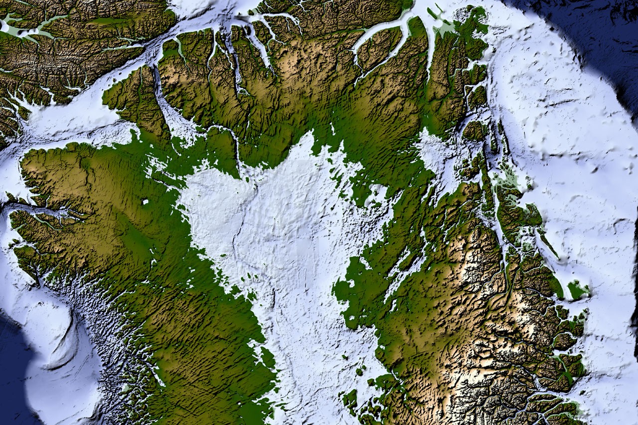
NASA-led researchers mapped 1,943 valleys under Greenland's ice from faint bumps in satellite maps of its surface, about a third of them new. The map is meant to improve future versions of BedMachine Greenland, a high-resolution dataset of the terrain beneath the ice.
The Scientist · Science desk
What happened
- About half the valleys already in BedMachine Greenland, mostly near the ice edge, run farther inland than that dataset shows, in some cases by hundreds of kilometers.
- Many of the valleys begin in the southern and eastern highlands, where the ice sheet is thought to have first formed.
- Beneath the eastern highlands sits a buried mountain range whose alpine landforms may have survived under the ice since at least the Pliocene.
- Wide branching angles suggest a groundwater network seeping upward helped carve the valleys before the ice sheet formed.
Compiled by The ScientistSomething wrong?How this is made
Why it matters
- capability Satellites already map the ice surface in fine detail, and those maps can now be turned into a picture of rock lying under ice more than 3 kilometers thick.
- exposure Interior ice above the valleys' newly traced inland reaches sits on the routes that faster flow is expected to follow as the ice sheet retreats.
- constraint The valleys were traced by hand, so any BedMachine update built on them inherits the mappers' judgement about which surface wrinkles mark a valley.
Ice Flow Perturbation Analysis starts from a physical fact about moving ice. When ice flows over a ridge or a valley, the buried topography leaves a faint signature on the ice surface [4]. Satellites map that surface in fine detail, and the researchers worked backward from its small bumps and dips to the shape of the rock [4]. The rock sits under an ice sheet of 1.7 million square kilometers, more than 3 kilometers thick at its thickest point [1]. No one has seen that landscape directly [2].
For modelling the ice, the roughly 650 new valleys [6] matter less than how far the known ones reach, because of what ice does inside a valley. Flow concentrates there and forms the glaciers that calve into fjords at the edge of the sheet [17]. Ice funnelled through a valley grows thicker, thicker ice flows faster, and faster flow cuts the valley deeper [17]. The carving shows most clearly along western Greenland. Joe MacGregor, a NASA cryospheric scientist and co-author of the study, likened that coast to Yosemite: "El Capitan after El Capitan." [20] "The better we understand the topography now," MacGregor said, "the better sense we'll have of what it will look like in the longer term." [19]
The thing this doesn't tell you is how deep the valleys are, or how well the surface-derived shapes match direct measurements of the bed. NASA's summary of the paper, published in Geophysical Research Letters [9], reports neither. NASA calls the result the most detailed and accurate view of the bed yet [3]. Depth matters to the feedback, since it is the thickening of ice in a valley that speeds its flow [17]. BedMachine Greenland does not carry the new valleys yet; the work is aimed at future versions of it [8]. NASA describes the benefit for projections of the ice sheet's future as potential [10].
The map also produced a geological puzzle. Many valleys in west-central Greenland are long, straight and aligned southwest to northeast. That orientation suggests tectonics set the paths along which water flowed and valleys formed [13]. "That's a riddle to us," MacGregor said [14]. "Greenland is justifiably usually treated as a rigid block of old rock that is simply translated as needed to accommodate the motion and interactions of other tectonic plates." [14]
What to watch
- Whether the next BedMachine Greenland release adopts the longer inland valleys, and how far that moves modelled fast flow into the interior.
- A comparison of the surface-inferred valley shapes with direct measurements of the bed, as a test of the method's accuracy and a source of depths.
- Tectonic work that explains the southwest-northeast alignment of the west-central valleys MacGregor called a riddle.