Science1 publisher2 min readPublished
Sand Creek fire cloud acted as its own mountain, lifting moist air into a pileus cap
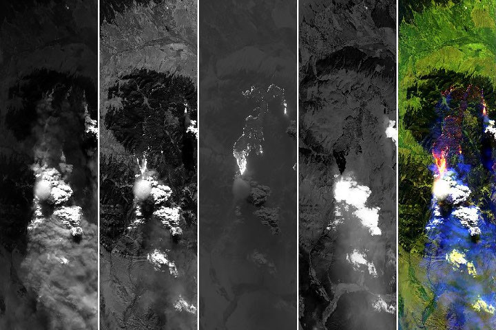
NASA's INSPYRE flight caught a pileus cap on a wildfire cloud over Montana's Sand Creek fire on August 11, visible in just one of its half-hourly scenes. NASA says researchers rarely see such a cap over a fire cloud in this much detail.
The Scientist · Science desk
What happened
- The images were taken at 5:40 p.m. local time by the MASTER sensor aboard one of NASA's ER-2 high-flying research aircraft.
- A natural-color frame shows the thin, circular cap atop the smoke turret, while a shortwave-infrared view maps the burned area and the active burning spots along the perimeter.
- At that moment the fire was making a rapid run up the western side of Mount Comet, with winds lined up along the drainage channels leading up the mountain.
- Volcanic plumes produce the same caps, and astronauts photographed one over the Sarychev volcano after its 2009 eruption.
Compiled by The ScientistSomething wrong?How this is made
Why it matters
- capability INSPYRE now has a case where one documented fire run on Mount Comet can be matched to the cloud response it drove, with the ground and the cloud measured at the same moment.
- constraint Imaging about every 30 minutes can show that a fire plume raises a pileus cap, but it cannot yet say how often fire plumes do so.
- constraint Until measured updraft speeds are published, the cap is only a qualitative sign of strong lift, and this plume cannot yet be ranked against thunderstorm updrafts.
Pileus clouds are well known to atmospheric scientists, who read them as a sign of especially vigorous convection [4]. One forms when a column of rising air runs into a moist enough layer of air above it [5]. Over Sand Creek, an updraft heated by the fire pushed air straight up and forced a moister horizontal layer above it upward. As that layer rose it cooled, and its water vapor condensed into the cap [6].
"But in this case, the pyrocumulus itself was the 'mountain,'" said Neil Lareau, INSPYRE's deputy project investigator [8]. He was comparing the plume with high ground, where air forced up a slope can also produce cloud [7]. According to NASA's account, the cap hints at what Lareau called "extreme updraft dynamics" within the plume and pyrocumulus [13]. Fire is one of several drivers of convection that produce pileus clouds, and severe thunderstorms make them too [19]. Researchers on NASA's CRYSTAL-FACE campaign in Honduras in 2002 reported thin cirrus near the tropopause above thunderstorms that were likely the products of pileus clouds [20].
MASTER records 50 channels [18]. On this pass its visible channels caught the pyrocumulus and cap as they developed, and its infrared channels caught the fire's extreme behavior at the surface. Downward-pointing radars on the same aircraft studied the cloud's structure [15]. "The whole scene is amazing," Lareau said [15]. "This scene is in many ways the core of what we're after with INSPYRE," he said [16]. "We were able to connect and map the surface fire dynamics to the convective plume to the cloud processes." [17]
Luck played a part. A pileus usually lasts only a few minutes before the convection beneath overtakes it [11]. The team imaged the plume roughly every 30 minutes [12]. The gap between frames is many times longer than the cloud's usual life, so a cap that forms and dissolves between passes is never recorded [1].
The claim here is narrow: a fire plume can push a moist layer aloft the way a mountain does. One well-documented case is enough to show that, and I think Sand Creek is that case. The thing this doesn't tell you is how hard the air was rising. NASA's account calls the updraft fast-rising and its dynamics extreme, but it does not report a measured speed or any radar results [2].
What to watch
- Publication of INSPYRE's radar analysis of the Sand Creek pyrocumulus, giving a number for how strongly the fire plume was rising.
- Whether later INSPYRE flights catch more pileus caps over fire clouds, the first step toward knowing how often fire plumes lift a moist layer this way.