Science1 publisher2 min readPublished
A mid-September heat dome put 41 million Americans inside extreme heat alert areas
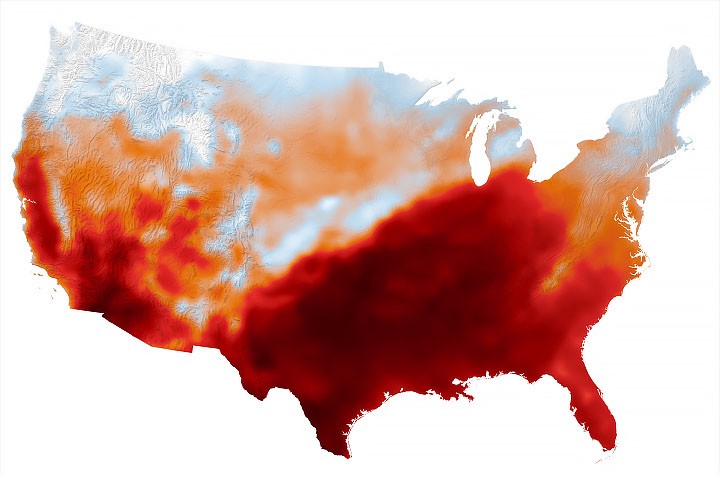
NASA Earth Observatory's map of September 15 pairs satellite data with the GEOS model to show air approaching 40 degrees Celsius across the south-central states. The 41 million figure beside it counts residents of National Weather Service alert areas.
The Scientist · Science desk
What happened
- Dallas hit 101 degrees Fahrenheit, Nashville 100 and Memphis 99, with Nashville breaking a daily-high record that had stood since 1927.
- NASA attributes the heat to a heat dome, in which upper-atmosphere high pressure pushes hot air to the surface and traps it while suppressing cloud and precipitation.
- NOAA reported that June through August was the warmest such period for the contiguous United States in a 132-year record, 0.4F above the marks set in 1936 and 2021.
Compiled by The ScientistSomething wrong?How this is made
Why it matters
- constraint Because the headline count is drawn from forecast-office alert areas, comparing it with a future year's figure tracks where the National Weather Service drew its polygons as much as where the air was hot.
- exposure Humidity, thin cloud and light winds pushed the felt conditions above the modeled air temperature, so the people inside the reddest parts of the map were carrying a heat load the map itself does not quantify.
- decision Emergency managers deciding when to stand down summer heat response now have a mid-September afternoon on which three major cities ran 12F or more above normal to argue against.
Forty-one million against 12 percent implies a base population of about 342 million [1]. The percentage is the more useful of the two numbers, because the count is administrative. National Weather Service extreme heat advisories, watches and warnings are issued over forecast areas, and the figure counts residents inside those areas on a single day [3].
The map is a different product. It shows air temperature at 2 meters above the ground for 4 p.m. Central Time on September 15, 2026 [1], built by combining satellite observations with temperatures predicted by a version of GEOS, the Goddard Earth Observing System model [2]. Michala Garrison made the image using GEOS-FP data from the Global Modeling and Assimilation Office at NASA Goddard [12]. The darkest reds mark air that approached or exceeded 40 degrees Celsius [4]. Meteorologists warned that high humidity, limited cloud cover and light winds could make temperatures feel higher than thermometer readings and raise the risk of heat-related illness [7], so what people felt ran hotter than the field the map plots.
Nashville reached 100 degrees Fahrenheit and broke a daily-high record set in 1927, 99 years earlier [8][2]. Dallas reached 101F and Memphis 99F [8]. All three cities were at least 12F above normal for the date [9], which places their normal mid-September highs at 89F, 87F and 88F or lower [3]. The day before, Nashville set a record-high minimum of 75F [10], the overnight low rather than the afternoon peak.
NASA attributes the heat to a heat dome, an area of high pressure in the upper atmosphere that pushes hot air toward the surface and traps it there. Convection slows, clouds and precipitation are suppressed, and sunlight reaches the ground relatively unhindered [6]. The hot air spanned large portions of Texas, Oklahoma, Arkansas, Missouri and Tennessee [5].
June through August was the warmest such period for the contiguous United States in a 132-year record, 0.4F above the previous marks from 1936 and 2021, according to NOAA [11].
That statistic covers June through August. September 15 falls outside it. One afternoon fixes a level, and a claim that alert-level heat now routinely reaches the third week of September would need September alert-area counts across many years, which this release does not contain [3].
What to watch
- Whether NOAA's September national climate report puts the month itself near record for the contiguous U.S., as its June-August report did for the summer.
- Whether the National Weather Service publishes September alert-area population counts across multiple years, which is what a lengthening-heat-season claim would need.
- Whether more record-high overnight minimums follow Nashville's 75F on September 14 as the season turns.