Science1 distinct publisher2 min readPublished
Puerto Rico held no drought at all three months before August 25, when the U.S. Drought Monitor put 44 percent of the territory in extreme drought and rationing was already running in several municipalities.
The Scientist · Science desk

Compiled by The ScientistSomething wrong?How this is made
The southwestern figure describes a failed wet season rather than a dry spell. The National Integrated Drought Information System reported that southern and southwestern areas received less than 20 percent of normal rain from mid-May through mid-July, a shortfall of 3 to 6 inches [5]. A place short by more than four fifths of its normal rain has a normal for that window of at most about 3.75 to 7.5 inches [3], and rain that actually arrived amounting to no more than a quarter of the shortfall: under 0.75 to 1.5 inches across two months [2].
The composition matters as much as the total. Extreme drought at 44 percent of the territory, inside a footprint where roughly three quarters was at least moderately dry, means close to 59 percent of the drought-affected area sat in the extreme class rather than at its edges [1]. Heat pushed the same way. San Juan logged one of its warmest Julys on record [6], and streamflow fell to record lows in waterways including the Rio Fajardo in the northeast [7]. None of this was foreshadowed by the early part of the year: late winter and early spring were wetter than normal across the U.S. Caribbean, according to the NIDIS report [18], and the island normally enters its wet season in May [17].
A drought class does not tell you when the taps come back. Rationing has been in effect in several municipalities since early August, according to news reports cited by NASA Earth Observatory [10], and observers have pointed to infrastructure as a factor worsening the shortages [11]. The U.S. Drought Monitor, produced by the National Drought Mitigation Center at the University of Nebraska-Lincoln with the USDA, NOAA and NASA [15], grades moisture conditions. It is not an inventory of stored water, and it does not count what a distribution network loses on the way to a household. Both of those decide a rationing schedule.
The reading the evidence supports is narrow and firm: the shortfall is quantified, and its end date is not known. The August assessments date the deficit precisely but do not indicate when rain returns. For anyone with water in their cost structure on the island, the operating input for the rest of 2026 is the allocation in front of them, not the seasonal outlook behind it.
Ranked by verification strength, evidence, and original report placement.
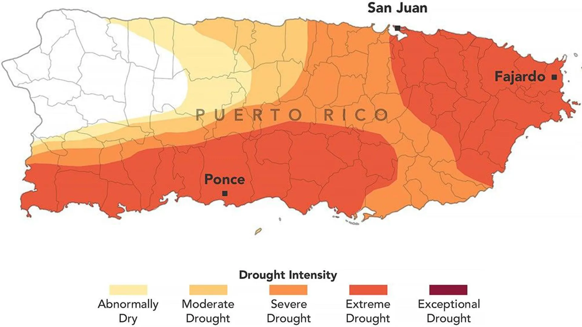
By August 25, 2026, extreme drought zones in eastern and southwestern parts of Puerto Rico's main island had expanded during the previous week and covered 44 percent of the territory, according to the U.S. Drought Monitor assessment.
By August 25, 2026, about three-quarters of Puerto Rico was experiencing at least moderate drought.
Three months earlier, none of Puerto Rico was classified as being in drought, and less than 20 percent of the territory was considered abnormally dry.
From mid-May through mid-July 2026, most of Puerto Rico received less than 60 percent of its normal precipitation, according to a National Integrated Drought Information System report.
Southern and southwestern areas of Puerto Rico received less than 20 percent of normal rainfall from mid-May through mid-July, a rainfall deficit of 3 to 6 inches (76 to 152 millimeters), according to NIDIS.
San Juan experienced one of its warmest Julys on record in 2026.
Distinct publishers with included, body-backed reporting in this cluster.
1 article · September 4, 2026
Follow any of these and your For You feed starts watching them — no settings page required.
science
A pole-on magnetar hands vacuum birefringence its first astrophysical candidate1 distinct publisher
science
Petermann's 76-square-kilometer ice island survived its first collision intact2 distinct publishers
science
Assimilating water vapor isotopes improved forecasts out to five days in a near-operational test1 distinct publisher
science
NASA-funded simulations shrink the heliosphere inside Earth's orbit three times in 14 million years1 distinct publisher
Evidence-backed comparisons of source perspectives and observed adoption signals. Read the methodology
Which Builder, Operator, and Investor concerns the observed source mix emphasized—not a truth score.
Evidence, demonstrated adoption, hype gap, incentives, and confidence are assessed independently, each on its own current evidence. How these are measured.
Official numbers, single pipe
The quantitative spine is strong and checkable: a dated U.S. Drought Monitor assessment and a NIDIS precipitation report, both federal products with archives. The reporting of them is not independent, though. NASA wrote it, ScienceDaily reprinted it, and the human half of the story thins out fast, with rationing sourced to unnamed news reports and the infrastructure argument to unnamed observers.
Authorities already acting on it
This assessment is not waiting for someone to use it. A territorial emergency was declared in late July, several municipalities were rationing water by early August, and by late August the federal government had designated more than two dozen Puerto Rican towns as disaster areas through a USDA process that reads these maps directly. The chain from map to relief is short and visibly in motion.
Slight: a ten-day-old snapshot cast as 'now'
The overshoot is in the tense, not the numbers. 'Extreme drought now covers 44%' describes August 25, published September 4, for a figure the Monitor revises weekly and which had already moved in the week before the snapshot. Everything else holds up under arithmetic: a 3-to-6-inch deficit at under 20 percent of normal implies barely an inch of rain in two months, which squares with record-low streamflow, and the damage claims stay carefully unquantified rather than dressed up.
Agency self-narration, no sales pitch
NASA's own communications shop produced this, and there is a second story folded into the first: 2026 is the year two NASA scientists joined the handful of people who author the weekly drought map. The drought is plainly real, but the framing also documents an agency deepening its stake in a product it helps supply data to. ScienceDaily adds no reporting and no scrutiny, only a credit line. Nothing here is selling anything.
Solid physically, thin downstream
Confident where the story rests on a monitoring product with a 27-year publication history and dated numbers; much less so past that line. The crop damage, the rationing and the infrastructure argument all arrive secondhand and unmeasured, and with one outlet carrying one agency's text there is no second reading of any of it.