Science1 publisher3 min readPublished
CIRES researchers suspect a recurring estuary weakened Petermann before its August calving
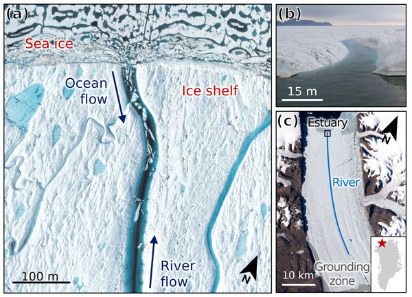
CIRES scientists measured a Petermann Ice Shelf river cutting below sea level to form an estuary that came and went from 2014 to 2018. A co-author suspects that cycle weakened the shelf ahead of its Manhattan-sized calving in August, though the imagery ends eight years earlier.
The Scientist · Science desk
What happened
- An iceberg the size of Manhattan broke off Greenland's Petermann Ice Shelf in August 2026, the glacier's largest calving since 2020.
- The Petermann estuary, where ocean water mixes with a surface meltwater river, was discovered in 2021 and is the first known on any ice shelf.
- A CIRES-led study in The Cryosphere measured for the first time how fast that river cut into the shelf, using channel elevations derived from satellite imagery.
- Images from 2013 to 2018 show the estuary formed in 2014, vanished, reformed late in 2016 and kept cycling until a 2018 crack cut the river off upstream.
Compiled by The ScientistSomething wrong?How this is made
Why it matters
- capability Monitors can now track a river mouth's height above sea level through a melt season from orbit and flag a channel close to becoming an estuary before ocean water gets in.
- constraint With the record ending eight years before the break, the estuary's role in the August calving is the co-authors' judgement and cannot be read directly from the published imagery.
- exposure If thinning makes it easier for rivers to cut to sea level, as Banwell expects, Greenland's four other shelves and Antarctica's fringing shelves are open to a failure route that rivers were thought to guard against.
"We've known for a couple of decades that lakes can be harmful to the overall health of an ice shelf, whereas rivers can actually be beneficial," said Alison Banwell, a CIRES research scientist and a co-author of the study [9][19]. Pooled meltwater can destabilize a shelf, as it did ahead of the Larsen B breakup in 2002 [8]. A river helps by carrying that water off the shelf into the ocean and reducing its weight [8].
Petermann's river started out as the helpful kind. Then it cut so deep that its mouth dropped below sea level. Warmer, salty ocean water began mixing with the meltwater and flowing backward up the channel [11]. The 2021 images that confirmed the estuary, in a study led by Alexandra Boghosian, showed chunks of sea ice floating up the river onto the shelf [7]. "Our new research suggests that estuaries can also be harmful," Banwell said [10].
The new paper adds depths and dates to that process [3]. The team worked out the channel's height above sea level through each melt season from satellite imagery, and tracked the cut from the river's surface down to the channel bed [5][11]. "We're using satellite data not just to look at where the water is and how deep it is, but also to look at elevation change over time, and how quickly the river is cutting into the ice surface," said Michela Savignano, the lead author and a doctoral student at CU Boulder and CIRES [12][19].
Banwell's case for harm rests on the estuary switching on and off [13]. "We think the process of the estuary forming and reforming over multiple melt seasons weakened the ice shelf due to the loading and unloading of ocean water, and potentially contributed to the calving event that happened in August of this year," she said [6].
The record behind that link stops in 2018. That year a crack running perpendicular to the ice flow cut the river off upstream of the estuary [13]. The calving came eight years later [1]. The observations cover one estuary on one shelf over six melt seasons [2], and the published summary reports neither the incision rates nor whether the estuary came back after 2018. I think the loading idea is plausible. The imagery described cannot separate it from whatever else happened to Petermann between 2018 and 2026.
For shelf monitoring, the concrete output is a condition that can be measured from orbit: a river mouth approaching sea level [5][11]. Banwell expects that condition to become easier to reach. "We think estuaries may become more common on other ice shelves as they melt and thin, which they're going to do at increasing rates in the future," she said. "It will be easier for a surface river to incise down to sea level." [15][16]
Savignano looked first at Greenland. "Only five ice shelves remain in Greenland, including Petermann, and estuaries could make them more prone to breakup," she said [17]. About 75% of Antarctica is surrounded by ice shelves [14]. There, she said, "estuaries could begin forming within 30 years" [18].
What to watch
- Petermann channel-elevation measurements after 2018, showing whether the river or a new one reached sea level again before the August 2026 calving.
- Whether the same satellite method finds river mouths nearing sea level on Greenland's four other ice shelves or on Antarctic shelves.
- The paper's own incision rates, and the basis for Savignano's estimate that Antarctic estuaries could form within 30 years.