Product1 distinct publisher2 min readPublished
A Seoul Tech team screened the Bundang Line with satellite InSAR, then sent laser scanning and ground-penetrating radar only to the structure that moved. The published work leaves the cost saving unmeasured.
The Product Desk · Product desk

Compiled by The Product DeskSomething wrong?How this is made
Somebody had already been inside that shaft. Visual inspection recorded multiple cracks and signs of previous repairs on the ceiling before any laser scanner was set up [7]. What the satellite pass contributed was the order of work: along a corridor that long [3], the difficulty was never spotting a cracked ceiling once you were standing under it, but deciding which structure got the site visit this quarter [5].
That is a modest description of a screening layer, and it maps onto a grid any asset owner can draw. Put area coverage on one axis and causal explanation on the other. Satellite InSAR covers wide areas and cannot by itself say what is causing the movement it sees [10]. Field survey explains a single site in detail and does not scale to an entire corridor [11]. The quadrant that would make staging unnecessary, wide coverage that also explains itself, is empty, which is why the Seoul National University of Science and Technology team chained three methods instead of choosing one [2]. Lead researcher Taeyong Park frames the payoff as characterising excavation and compaction defects in more depth, not as better detection [12].
The discriminator the funnel rests on is thin. The shaft's cumulative settlement runs about three times the area-wide maximum, an excess of roughly 10 millimetres [14]. Under that flag sit the two confirming layers, laser scanning to describe how the structure is deforming and radar to look at what is beneath it [17], which is how the team argued the anomaly was real rather than an artefact of remote sensing [13]. The seasonal-trend decomposition matters more than its name suggests: pulling seasonal fluctuation out of the long-term settlement signal [4] is what stops a crew being dispatched to the same shaft every spring.
The cost case for triage is argued rather than shown. The published account carries no crew-hours, no cost per kilometre against a uniform survey, no uncertainty bounds on the millimetre figures, and one confirmed anomaly [15]. A single clean positive shows the chain can work, but it cannot give the false-positive rate, and that is the number deciding whether the confirming layers are cheap triage or a standing charge on the maintenance budget.
The framework implies a forcing function for any corridor with layered monitoring: each layer should be tied to the one decision it is allowed to authorise by itself. In this framework, InSAR authorises a visit, laser scanning authorises opening the ground, radar authorises a remediation design [17]. A layer that authorises nothing on its own is telemetry, and it should be budgeted as telemetry rather than counted as inspection.
Ranked by verification strength, evidence, and original report placement.
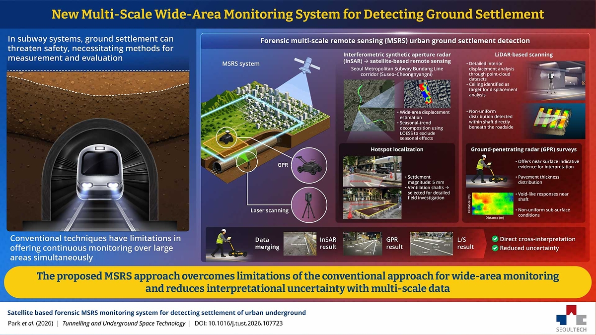
Researchers at Seoul National University of Science and Technology developed a forensic multi-scale remote sensing (MSRS) framework that combines satellite radar, laser scanning and ground-penetrating radar to find suspicious areas, investigate them in detail, and probe what may be happening underground.
Researchers had previously paired technologies such as InSAR with GPR or laser scanning; the new approach links three methods in a staged investigation.
The team tested MSRS along more than 16 kilometres of the Seoul Metropolitan Subway Bundang Line corridor between Suseo Station and Cheongnyangni Station.
The team analysed the corridor over the long term and used seasonal-trend decomposition using LOESS, a statistical method that helped separate seasonal fluctuations from longer-term settlement.
The wide-area InSAR scan identified a ventilation shaft with a distinct settlement signal, letting the researchers focus attention on that spot rather than investigating every location along the route in equal detail.
The satellite analysis found settlement of up to about 5 millimetres across the study area, while the selected ventilation shaft and its surrounding area showed maximum cumulative settlement of about 15 millimetres, and the settlement was progressive.
Distinct publishers with included, body-backed reporting in this cluster.
1 article · August 29, 2026
Follow any of these and your For You feed starts watching them — no settings page required.
science
Radar found a 1256 convent a metre under a Roskilde pitch before the diggers arrived1 distinct publisher
invest
Sarsia bets EUR 3.7M that the cheapest low-carbon concrete is the concrete already standing1 distinct publisher
science
The Sacramento Valley's Aquifers Did Not Just Empty. Some of Them Broke.1 distinct publisher
Evidence-backed comparisons of source perspectives and observed adoption signals. Read the methodology
Which Builder, Operator, and Investor concerns the observed source mix emphasized—not a truth score.
Evidence, demonstrated adoption, hype gap, incentives, and confidence are assessed independently, each on its own current evidence. How these are measured.
Specific numbers, one retelling, no error bars
Every figure in this story — 16 kilometres, 5 millimetres across the area, 15 at the shaft — reaches us through Interesting Engineering's account of a paper in Tunnelling and Underground Space Technology that no one else in our coverage has read. The account earns some trust by being concrete: named journal, named corridor, named terminal stations, named lead author, and three instrument results that point the same way. What it never supplies is the one thing a millimetre-scale claim needs, an uncertainty band, so a reader cannot tell whether 15 millimetres of cumulative settlement clears the noise of a satellite time series or merely sits at its edge.
One corridor, run by its own inventors
The framework has been used exactly once, on one subway line, by the people who designed it. Nobody responsible for that line is quoted; the line about giving infrastructure managers a way to prioritise inspections is the researchers' hope, not a contract. A journal publication and a real field campaign on live infrastructure are more than a simulation, which is why this is not zero — but it is the bottom rung, and Interesting Engineering reports no second site, no repeat pass and no agency evaluating it.
Paradigm shift resting on one already-cracked ceiling
The reporting is more disciplined than the ambition inside it. Interesting Engineering prints the caveat that the method does not automatically establish the cause of every anomaly and that underground conditions are complex. Set against that, the quoted goal is nothing less than moving urban disaster management from reactive to proactive and reducing sudden sinkholes — and the demonstration is a single ventilation shaft whose ceiling was already visibly cracked and previously patched when the surveyors arrived. The staging logic is plausible and cheap to believe; the gap is that it has not yet been shown to find anything that ordinary inspection would have walked past.
Only the authors get to speak
There is one interested party in this story and no counterweight. Both quotes come from the lead researcher, whose framework and paradigm-shift framing are what is being assessed, and the shape of the piece — problem, method, vindication, vision — follows a university announcement closely. No funding source is named, no industrial partner, no vendor of InSAR or GPR services, and no independent tunnelling engineer is asked whether void-like radar returns near an old shaft are unusual. None of that implies anything is hidden; it means nobody in the reporting had a reason to make the method look worse than it does.
Nothing contradicts it, nothing corroborates it
We are reading one outlet with no dissent, describing work that is mostly descriptive rather than contentious — a reasonable place to stand. The ceiling on our confidence is the paper itself, which none of this coverage quotes: whether the LOESS decomposition adequately separated seasonal soil swelling from real settlement, and whether 15 millimetres is significant against the instrument's own error, are exactly the questions we cannot answer from a secondhand summary.