Science1 publisher2 min readPublished
ORNL's new global population dataset pairs each estimate with a measure of uncertainty
LandScan Mosaic estimates people from building height, floor count and use type, with machine learning filling the gaps in sparse regions. ORNL says it is the first globally available population release to publish confidence measures.
The Scientist · Science desk
What happened
- Oak Ridge National Laboratory has released LandScan Mosaic, a global population dataset that estimates where people are by modeling how buildings are used and occupied through the day.
- The named output is ambient population, the average number of people present in a place over a 24-hour period, including daily movement between homes, workplaces and schools.
- The LandScan program was established in 1999, and the earlier LandScan Global dataset introduced the ambient population concept for emergency response and risk assessment work.
Compiled by The ScientistSomething wrong?How this is made
Why it matters
- decision A published confidence measure changes what a reviewer can ask after a staging call: not only which count was used, but how wide the interval around it was.
- constraint A 24-hour average cannot answer a question about 10 a.m., so anyone who needs a daytime denominator cannot read it off an ambient value.
- exposure In places where building records were sparse, the population figure now rests on imputed height, floor count and use type, so the imputation is what a user there has to interrogate.
- precedent A global raster distributed with uncertainty attached gives buyers a comparison point to hold other population products to.
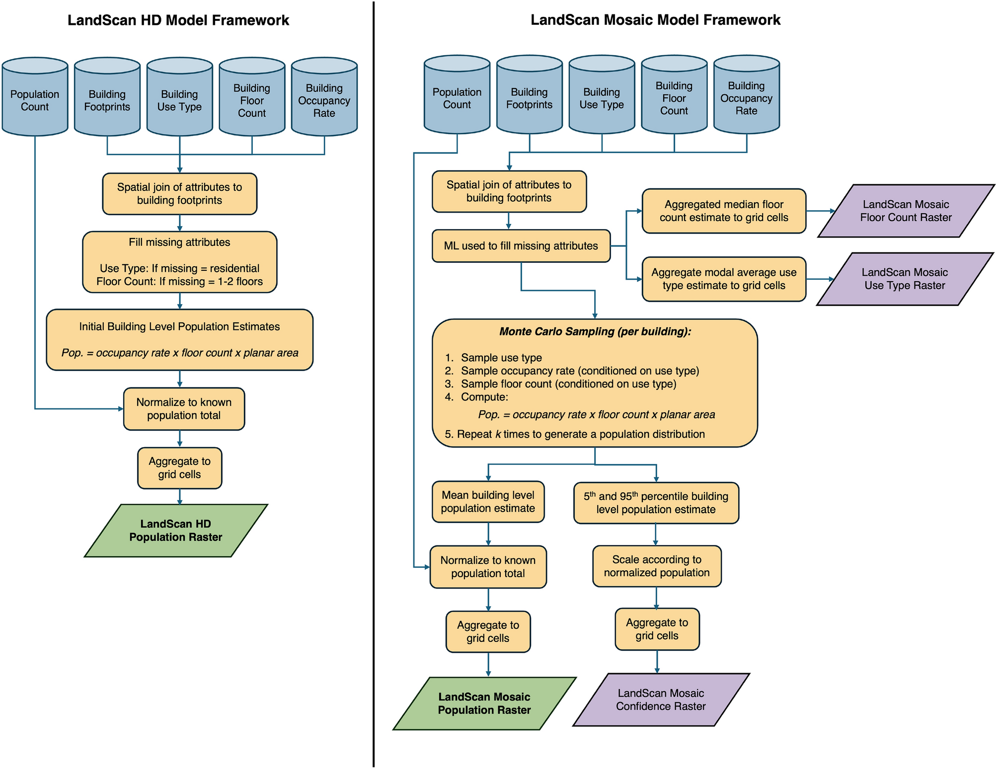
ORNL says the usual approach to mapping people leans largely on pixels from satellite imagery, and that Mosaic instead works building by building [2]. Each structure carries a height, a floor count, a function and a use type, and where those attributes were never recorded, a machine learning model estimates them. ORNL says that is what allows consistent high-resolution modeling in regions where building information is sparse [3]. Standardized occupancy distributions then describe how residential, commercial and industrial buildings fill [9]. Movement between homes, workplaces and schools reaches the estimate through those occupancy assumptions [4].
The uncertainty layer is the part the lab is claiming as new. Daniel Adams, an R&D scientist at ORNL and lead author of the Scientific Reports paper on the methodology, said that to his team's knowledge this is the first globally available population dataset release with these characteristics [6]. "Decision makers often need to act before perfect information is available," Adams said [10]. Pairing estimates with transparent measures of uncertainty, he said, "helps users understand not only where people are likely located, but also how confident they can be in each estimate" [11]. The announcement does not state a grid resolution, the width of a typical uncertainty interval, or an error figure against ground counts [16].
Ambient population itself is older than this release. LandScan Global pioneered the idea of modeling a person's full activity space across 24 hours, and the program was established in 1999 for emergency response, risk assessment and national security work [8]. Mosaic adds the building-level route to that number and a confidence measure beside it [3][5].
An ambient value is one number per location for the whole day [4]. Whenever occupancy varies across that day, the mean sits below the daytime peak, so a planner staging for a weekday business district is reading a figure lower than the crowd that will be in it at 10 a.m. [15]. ORNL lists improved temporal and location specificity compared with LandScan Global among the release's innovations [7], and names ambient population as the output [4].
The lab expects the dataset to serve disaster response, humanitarian assistance, infrastructure planning and national security missions worldwide [14]. Marie Urban, principal investigator for the LandScan program, said the multidisciplinary staffing is what makes the work possible, describing a team that can "bring together computer scientists, data scientists, geographers, people with expertise from different backgrounds" [13]. Urban said the group is now using historical population and building development data to understand how population and landscape change over time [12].
What to watch
- Validation numbers in the Scientific Reports methodology paper: error against ground counts, and how wide the uncertainty intervals get by region.
- Whether ORNL distributes time-sliced layers, hourly or day and night, alongside the 24-hour ambient value.
- Whether Urban's historical building development work produces a back-cast series users can run trends on.