Science1 publisher2 min readPublished
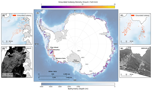
A master's project mapped 39,619 grounded icebergs holding Antarctic sea ice in place
A University of Tasmania master's project has produced the first continent-wide, high-resolution census of the icebergs grounded around Antarctica, the anchors that keep coastal fast ice from drifting off into the Southern Ocean.
The Scientist · Science desk
What happened
- The published inventory lists 39,619 grounded icebergs around Antarctica with a combined area of 13,430 square kilometres, mapped from Sentinel-1 radar by a deep learning detector.
- Grounded icebergs turn up along 57 percent of the Antarctic coastline, and 14 percent of the coastline accounts for 80 percent of them.
- No complete large-scale map of grounded icebergs existed before Kaihong Jiao began his master's project with the Australian Antarctic Program Partnership at the University of Tasmania.
Compiled by The ScientistSomething wrong?How this is made
Why it matters
- capability Groups modelling coastal ice stability get a public map of the anchors at the sub-kilometre scale where the clusters form, which Jiao offers as a baseline for that work.
- constraint The class that dominates the census averages about twelve times the detection floor, so a recount on a coarser sensor would delete most of the inventory and a finer one would enlarge it. Cross-sensor comparisons will need reprocessing, not differencing.
- exposure Four fifths of the anchoring bergs sit on about one seventh of the coastline, so the coastal sectors whose fast ice depends on the fence are a short and identifiable list.
- decision Anyone treating this as a baseline has to decide what one year of mapping means for objects that stay put for anything between days and decades.
Divide the mapped area by the count and the average grounded iceberg comes to 0.34 square kilometres, about 34 hectares [1]. The census covers 2025 [7]. The class the authors call tiny, anything under one square kilometre, works out to roughly 36,800 bergs covering about 7,250 square kilometres, an average of some 20 hectares each [2]. The other 7 percent, about 2,770 bergs, hold the remaining 6,180 square kilometres and average 2.2 square kilometres apiece [5].
The first of those figures depends on where the detector stops seeing. Jiao's processing chain brought the smallest recognisable iceberg down to 1.6 hectares, four acres [10]. So the tiny bin runs from 1.6 hectares up to 100, a span of about 62 to one, and its average member sits around twelve times above the floor [6][3]. A census that could only resolve bergs above one square kilometre would have listed about 2,770 objects instead of 39,619 [8]. "Traditionally, iceberg monitoring has relied heavily on manual analysis of satellite imagery," Jiao said [5].
The bergs are not spread evenly. They appear along 57 percent of the coastline, and 14 percent of the coast holds 80 percent of them [9]. Per kilometre of shoreline, that concentrated stretch is about twelve times as dense as the rest of the berg-bearing coast [4]. Along the remaining 43 percent, the dataset lists none [7].
The small ones matter because of the geometry the authors describe. Dense clusters in shallow water act as posts that catch and hold the landfast ice shielding Antarctic ice shelves from the Southern Ocean; the paper calls this the picket fence effect [12]. That fast ice in turn holds back land ice from slipping into the ocean, and supports habitat and nutrients for marine ecosystems [3].
The sensitivity argument is an inference from the size distribution, not an observed trend. Small bergs melt through and unground sooner than large ones as the ocean warms, and the authors write that this could trigger abrupt changes in the stability of landfast ice [13]. The phys.org account does not report accuracy figures for the detector against manually mapped scenes [16]. The dataset is published in Earth System Science Data by authors from the Institute for Marine and Antarctic Studies, the Australian Antarctic Division and Geoscience Australia [6]. "Our public dataset offers a crucial new baseline for modeling coastal ice stability and understanding broader environmental changes," Jiao said [14].
What to watch
- A second year processed the same way would turn a 2025 snapshot into a change signal for grounding and ungrounding.
- Whether landfast ice models actually ingest the Earth System Science Data release, and which groups do it first.
- Whether validation figures against manually mapped scenes appear in the paper itself.