Product1 distinct publisher3 min readPublished
The resolution binds nobody, which leaves the projection default sitting where it always was, inside a product decision. Mercator keeps the jobs that involve measuring and navigating, while everything drawn to be compared has run out of excuses.
The Product Desk · Product desk

leadership
MapQuest converts a map-label refusal into the top of the App Store2 distinct publishers
product
Former CMA official asks a London tribunal to price Apple's tracking prompt at £2bn1 distinct publisher
invest
Samsung Finally Has Foundry Pricing Power, and It Is Charging China For It3 distinct publishers
product
Google closes the UK Play Store fee case at 26p in the pound1 distinct publisher
Compiled by The Product DeskSomething wrong?How this is made
The projection argument in a charting config gets typed once, during a sprint, by someone who is not thinking about Togo. It stays unread until an outside document names it.
Two different products get called a map, and they carry different obligations. One routes a driver and zooms to a street corner. Mercator earned that job honestly: it renders circles of latitude and meridians of longitude as straight lines and it preserves angles, which is what navigators needed when it was devised in the 16th century and what made it attractive to Google and others assembling mapping services centuries later [7][8]. The other product is a picture of the world sitting still, a coverage map or the revenue-by-country choropleth on an all-hands slide. It has no navigational job at all, and it is where Mercator's documented distortion does the damage: landmasses toward the poles read larger than they are, while those near the equator read smaller [9]. Gizmodo lists the inflated group as North America, Europe and Russia, and the diminished group as Central and South America, the Indian subcontinent, southern and central Asia, and Africa [10]. African countries have objected to that treatment of the continent for years [14].
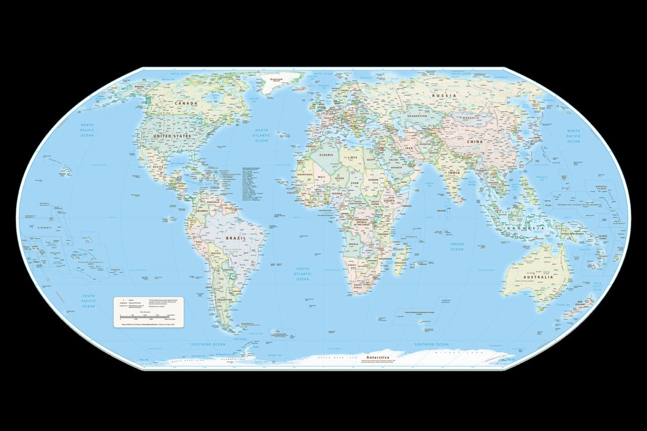
The replacement on offer is a 2017 design, distinct from the 1970s classroom poster. Equal Earth was created in 2017 specifically to depict relative areas better than Gall-Peters, the older equal-area projection [5], which puts roughly five centuries between the two options a team is now choosing between [13].
This carries no compliance weight. The resolution binds nobody, and Gizmodo's read is that its force runs entirely through pressure on publishers and tech companies [2]. What exists is a citable request with a national sponsor, an African Union endorsement, and, according to Reuters, exactly one country on record against it [3]. That combination turns up in a partner review or a procurement questionnaire, not in a filing.
The reason to expect movement anyway is what the same season showed about how map defaults actually get set. Gizmodo describes Google and Apple as rushing to implement Trump's attempt to redraw the map around Lake Ontario [11]. That is data, not scandal: geographic labels at the two largest consumer map vendors move on political request, quickly, when the requester matters commercially. The UN request arrives with better arithmetic behind it and far less leverage.
So sort the map surfaces you own on two questions. Does anyone measure or navigate on this one, and does anyone outside the company compare areas on it. Measure-and-navigate surfaces keep Web Mercator, because the resolution offers a delivery driver nothing, and even Gizmodo grants that the conformal, north-preserving behavior is useful at small scales [12]. Compare surfaces move to Equal Earth, and the work there is a re-export and a design system asset, not a migration. The mixed cell, the interactive world dashboard, is where the argument will actually happen, and the workable answer is to switch by zoom: equal area at world view, Mercator once someone is looking at a city.
The evidence says nothing about whether users notice a projection change, and no retention or usage-depth number is going to arrive to settle it. That leaves the choice resting on what each map is for.
Ranked by verification strength, evidence, and original report placement.
On Friday the UN approved a resolution sponsored by Togo and endorsed by the African Union asking for official adoption of the Equal Earth projection to replace the Mercator projection.
According to Reuters, the United States was the only country to vote against the resolution.
Togo's Foreign Minister Robert Dussey told Reuters on Friday: "A fair world begins with a fair map."
The Equal Earth projection was created in 2017 as a way of providing a more accurate depiction of the relative sizes of different areas than the Gall-Peters projection, an older equal-area projection.
Equal Earth is a pseudocylindrical projection: it preserves parallel circles of latitude, those circles decrease in radius toward the poles, and its meridians of longitude are curved.
The Mercator projection was devised in the 16th century as a navigational aid, rendering circles of latitude and meridians of longitude as straight lines and preserving angles.
Distinct publishers with included, body-backed reporting in this cluster.
1 article · September 4, 2026
Follow any of these and your For You feed starts watching them — no settings page required.
Evidence-backed comparisons of source perspectives and observed adoption signals. Read the methodology
Which Builder, Operator, and Investor concerns the observed source mix emphasized—not a truth score.
Evidence, demonstrated adoption, hype gap, incentives, and confidence are assessed independently, each on its own current evidence. How these are measured.
Single account, wire facts at one remove
The cartography in this story is checkable by anyone with a globe and a projection library: Mercator's straight latitude lines and conformality, Equal Earth's curved meridians and shrinking parallels, and the size distortion that follows from mapping equal-radius circles onto a cylinder. The political half is weaker in kind. The two hardest facts, that the resolution passed and that the United States stood alone against it, are Reuters' reporting relayed inside Gizmodo's essay, and the piece supplies no vote count, no resolution text and no reason from the US delegation.
No product has moved
One institutional endorsement and nothing downstream of it. Gizmodo names no atlas, textbook publisher, platform or API that has switched to Equal Earth or said it would, and Web Mercator remains the default the piece is arguing against. The only map that demonstrably changed here is a lake label, which Google and Apple altered fast on Gizmodo's account. That shows how quickly the companies can move a default when they want to, which is a different matter from any actual movement toward this projection.
Mild overreach on momentum
Gizmodo's headline claim is accurate and its technical concession is honest: it grants that Web Mercator's angle preservation still earns its keep. The stretch is in implied momentum. 'Could help put pressure on publishers and tech companies' carries a lot of the piece, and pressure on a company's projection choice sits some distance from a company changing it. The rhetorical close, that people find ways of doing things when they want to, reads as forecast dressed as inference.
Declared position, nothing to sell
Gizmodo writes with an open stance rather than a stake. Equal Earth is free and unowned, so nobody in the story profits from its adoption, and the outlet's interest is editorial: the piece opens on Trump and the lake, calls Equal Earth 'clearly superior', and pre-empts objectors before they arrive. That shows up as selection rather than distortion. The objections it engages are cost and inertia; the technical reasons a mapping engineer keeps a conformal projection in the pipeline get a sentence of credit and no examination.
Solid on geometry, thin on the vote
How the projections behave is not in doubt, and the direction of the story, an African Union-backed push against a 16th-century default, is coherent with the resolution's sponsorship. What we lack is a second account of the room: the tally, the US rationale, and the resolution's actual wording all rest on one outlet quoting a wire. That's solid enough for us to report on, though a mapping team would want more before planning a migration around it.